Lêer:AMH-5603-NA Map of Algoa Bay.jpg

Oorspronklike lêer (2 400 × 1 864 piksels, lêergrootte: 845 KG, MIME-tipe: image/jpeg)
Opsomming
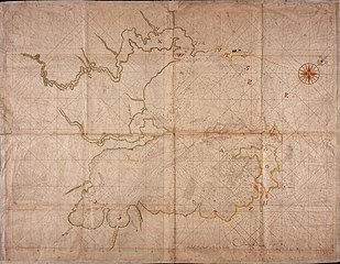
Nederlands: Kaart van de Algoa baai
English: Map of Algoa Bay( |
||||||||||||||||||||||||
|---|---|---|---|---|---|---|---|---|---|---|---|---|---|---|---|---|---|---|---|---|---|---|---|---|
| Outeur |
Nederlands: Cornelis Heeremans (landmeter / kaartenmaker), Wilhelm (Jansz.) Blaeu (drukker)
English: Cornelis Heeremans (land surveyor / mapmaker), Wilhelm (Jansz.) Blaeu (printer) |
|||||||||||||||||||||||
| Titel |
Nederlands: Kaart van de Algoa baai
English: Map of Algoa Bay |
|||||||||||||||||||||||
| Beskrywing |
Nederlands: Titel catalogus Leupe (NA): Kaart van de Delagaobaai.
Kompaslijnen gedrukt bij Willem Blaeu (dit gedrukte papier werd ook na diens sterven in 1638 nog dikwijls gebruikt). Notities verso: De Delagoa baai van Afrika [in potlood] / 23 [in potlood] / No. 2.English: Title in the Leupe catalogue (NA): Kaart van de Delagaobaai.
Compass lines printed by Willem Blaeu (this printed paper was used often afther his death in 1638). Notes on reverse: De Delagoa baai van Afrika [in pencil] / 23 [in pencil] / No. 2. |
|||||||||||||||||||||||
| Datum | circa 1680 | |||||||||||||||||||||||
| Tegniek |
Nederlands: ingekleurde tekening op papier
English: coloured drawing on paper |
|||||||||||||||||||||||
| Dimensies | Hoogte: 104 cm; breedte: 80 cm | |||||||||||||||||||||||
| Versameling |
|
|||||||||||||||||||||||
| Inventarisnommer |
NL-HaNA_4.VELH_103 (old number: VELH0103) |
|||||||||||||||||||||||
| Inskripsies |
-
author: Gedruckt by Wilhelm Blaeu / Cornelis Heeremans |
|||||||||||||||||||||||
| Opmerkings |
English: Subjects: chart / map / plan, compass / dial
Nederlands: Onderwerpen: plattegrond / kaart, kompas / windroos
English: Post: this image is related to a VOC trading post called Maputo |
|||||||||||||||||||||||
| Bron/Fotograaf |
|
|||||||||||||||||||||||
| Toestemming (Hergebruik van die lêer) |
|
|||||||||||||||||||||||


| Objekligging | | Hierdie en ander beelde in: OpenStreetMap |
|---|
Lêergeskiedenis
Klik op die datum/tyd om te sien hoe die lêer destyds gelyk het.
| Datum/Tyd | Duimnael | Dimensies | Gebruiker | Opmerking | |
|---|---|---|---|---|---|
| huidig | 08:41, 11 Junie 2014 | | 2 400 × 1 864 (845 KG) | HuskyBot | == {{int:filedesc}} == {{Artwork |title = {{nl|1=Kaart van de Algoa baai}} {{en|1=Map of Algoa Bay}} |description = {{nl|1=Titel catalogus Leupe (NA): ''Kaart van de Delagaobaai''. Kompaslijnen gedrukt bij Wil... |
Lêergebruik
Die volgende bladsy gebruik dié lêer:
Globale lêergebruik
Die volgende ander wiki's gebruik hierdie lêer:
- Gebruik in de.wikipedia.org
- Gebruik in el.wikipedia.org
- Gebruik in en.wikipedia.org