Lêer:French synergy ESA354897.jpg

Oorspronklike lêer (4 016 × 2 953 piksels, lêergrootte: 18,38 MG, MIME-tipe: image/jpeg)
Opsomming
| Beskrywing |
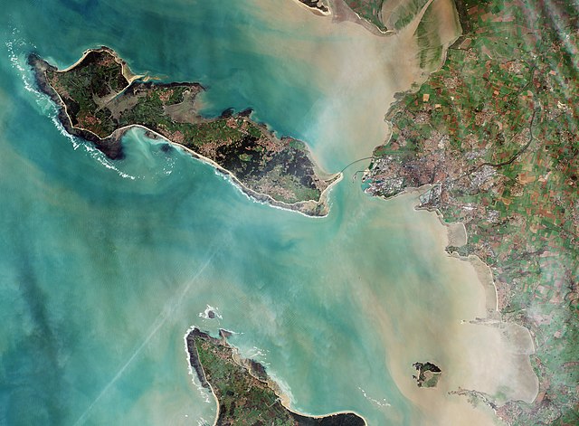
English: Capital of the Charente-Maritime department in western France, La Rochelle and surroundings are featured in this Sentinel-2A image, captured on 26 December 2015.
Home to some 80 000 people, La Rochelle is a city and a seaport on the Bay of Biscay, a part of the Atlantic Ocean, connected to the Île de Ré by a 2.9 km-long bridge, clearly visible in the centre of the image. La Rochelle and surrounding areas sit on layers of limestone dating back some 160 million years, when a large part of France was under water. These various layers containing many small marine fossils are traditionally used as the main construction material throughout the region. The coastal area is dominated by sandy beaches, which are visible as white lines somewhat inland. Between the beach and the water-line, darker sand and silt layers are visible, which are exposed in this image taken during low tide. The 4–5 m tidal range creates a heaven for wild mussels and oysters, making it one of the major places for shell farming in Europe. Also visible just north of the city is the La Rochelle-Ile de Ré airport. Thanks to the high-resolution multispectral instrument on Sentinel-2A, we can clearly make out the various agricultural fields around the city and surrounding towns, as well as on the Île de Ré Island. Part of the Natural Reserve of the Bay of Aiguillon is visible at top right. It is one of the most important reserves in France, hosting hundreds of thousands of migratory water birds every year. It is a place of synergy between land and sea, between saltwater and freshwater, and between nature and humankind. Sentinel-2A has been in orbit since 23 June 2015 as a polar-orbiting, high-resolution satellite for land monitoring, providing imagery of vegetation, soil and water cover, inland waterways and coastal areas. This image is also featured on theEarth from Space video programme. |
| Datum | |
| Bron | http://www.esa.int/spaceinimages/Images/2016/02/French_synergy |
| Outeur | European Space Agency |
| Toestemming (Hergebruik van die lêer) |
Copernicus Sentinel data (2015)/ESA,CC BY-SA 3.0 IGO |
| Ander weergawes |
|
| Title | French synergy |
| Set | Earth observation image of the week |
| System | Copernicus |
| Mission | Sentinel-2 |
| Location | France |
| Activity | Observing the Earth |
| Keywords | City; Coast; Coast line; Ports; Ocean; Satellite image |

Lisensiëring
- U is vry:
- om te deel – die werk kopieer, versprei en deurgee
- om te hermeng – om die werk aan te pas
- Onder die volgende voorwaardes:
- naamsvermelding – U moet die nodige krediet gee, 'n skakel na die lisensie verskaf en aandui of daar veranderinge aangebring is. U mag dit op enige redelike manier doen, maar nie op enige manier wat daarop dui dat die lisensiegewer u of u gebruik onderskryf nie.
- insgelyks – As u die materiaal hermix, transformeer of voortbou, moet u u bydraes versprei onder die dieselfde of versoenbare lisensie as die oorspronklike.

|
This image contains data from a satellite in the Copernicus Programme, such as Sentinel-1, Sentinel-2 or Sentinel-3. Attribution is required when using this image.
Naamsvermelding: Contains modified Copernicus Sentinel data {{{year}}}
The use of Copernicus Sentinel Data is regulated under EU law (Commission Delegated Regulation (EU) No 1159/2013 and Regulation (EU) No 377/2014). Relevant excerpts:
Free access shall be given to GMES dedicated data [...] made available through GMES dissemination platforms [...].
Access to GMES dedicated data [...] shall be given for the purpose of the following use in so far as it is lawful:
GMES dedicated data [...] may be used worldwide without limitations in time.
GMES dedicated data and GMES service information are provided to users without any express or implied warranty, including as regards quality and suitability for any purpose. |
Lêergeskiedenis
Klik op die datum/tyd om te sien hoe die lêer destyds gelyk het.
| Datum/Tyd | Duimnael | Dimensies | Gebruiker | Opmerking | |
|---|---|---|---|---|---|
| huidig | 23:47, 2 Januarie 2021 | | 4 016 × 2 953 (18,38 MG) | StellarHalo | higher resolution |
| 21:30, 7 Mei 2017 |  | 1 920 × 1 412 (2,84 MG) | Fæ | European Space Agency, Id 354897, http://www.esa.int/spaceinimages/Images/2016/02/French_synergy, User:Fæ/Project_list/ESA |
Lêergebruik
Die volgende bladsy gebruik dié lêer: