Lêer:Samaritan communities map.png
Geen hoër resolusie is beskikbaar nie.
Samaritan_communities_map.png (500 × 333 piksels, lêergrootte: 16 KG, MIME-tipe: image/png)
Opsomming
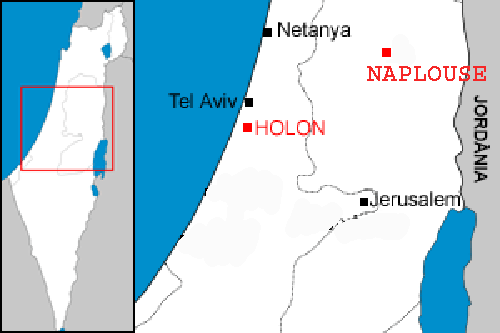
| Beskrywing | Localization of the two samaritan communities : Holon in Israel, and Nablus in the west bank. |
| Datum | |
| Bron | Image:Localització de Holon.png |
| Outeur | modified by Christophe cagé 09:54, 4 January 2007 (UTC) |
| Toestemming (Hergebruik van die lêer) |
see license (Public domain) of original image |
| Ander weergawes | Image:Localització de Holon.png |
Lisensiëring
| |
This work has been released into the public domain by its author, Rf, at the Engels Wikipedia project. This applies worldwide. In case this is not legally possible: |
Lêergeskiedenis
Klik op die datum/tyd om te sien hoe die lêer destyds gelyk het.
| Datum/Tyd | Duimnael | Dimensies | Gebruiker | Opmerking | |
|---|---|---|---|---|---|
| huidig | 09:54, 4 Januarie 2007 | | 500 × 333 (16 KG) | Christophe cagé | {{Information |Description=Localization of the two samaritan communities : Holon in Israel, and Nablus in the west bank. |Source=Image:Localització de Holon.png |Date=~~~~ |Author=modified by ~~~~ |Permission=see license (Public domain) of original |
Lêergebruik
Die volgende bladsy gebruik dié lêer:
Globale lêergebruik
Die volgende ander wiki's gebruik hierdie lêer:
- Gebruik in fr.wikipedia.org
- Gebruik in it.wikipedia.org
- Gebruik in nl.wikipedia.org
- Gebruik in pt.wikipedia.org