Lêer:South Africa 2011 LGE council winners.svg

Size of this PNG preview of this SVG file: 684 × 599 piksels. Ander resolusies: 274 × 240 piksels | 548 × 480 piksels | 876 × 768 piksels | 1 168 × 1 024 piksels | 2 337 × 2 048 piksels | 809 × 709 piksels.
Oorspronklike lêer (SVG-lêer, normaalweg 809 × 709 piksels, lêergrootte: 1,67 MG)
Opsomming
| Beskrywing |
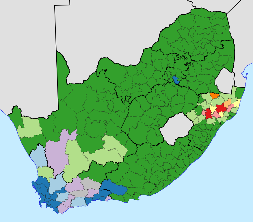
English: Map of South Africa, showing for each local and metropolitan municipality the state of the municipal council after the election of 18 May 2011.
African National Congress majority
No majority, ANC leading party
Democratic Alliance majority
No majority, DA leading party
Inkatha Freedom Party majority
No majority, IFP leading party
National Freedom Party majority
No majority, NFP leading party
No majority, another party leading
No majority, ANC-DA tie
No majority, ANC-IFP tie |
| Datum | |
| Bron | Eie werk, based on File:Map of South Africa with municipal borders (2011).svg |
| Outeur | Htonl |
.svg)
Lisensiëring
Ek, die outeursreghouer van hierdie werk, publiseer dit onder die volgende lisensie:

|
Toestemming word verleen tot die kopiëring, verspreiding en/of wysiging van hierdie dokument onder die voorwaardes van die GNU-lisensie vir vrye dokumentasie, weergawe 1.2 of enige latere weergawe uitgegee deur die Stigting vir Vrye Sagteware, sonder Invariante Dele, geen Voorbladtekste en geen Agterbladtekste. 'n Kopie van hierdie lisensie is ingesluit in die afdeling getiteld GNU Free Documentation License. |
This file is licensed under the Creative Commons Attribution-Share Alike 4.0 International, 3.0 Unported, 2.5 Generic, 2.0 Generic and 1.0 Generic license.
- U is vry:
- om te deel – die werk kopieer, versprei en deurgee
- om te hermeng – om die werk aan te pas
- Onder die volgende voorwaardes:
- naamsvermelding – U moet die nodige krediet gee, 'n skakel na die lisensie verskaf en aandui of daar veranderinge aangebring is. U mag dit op enige redelike manier doen, maar nie op enige manier wat daarop dui dat die lisensiegewer u of u gebruik onderskryf nie.
- insgelyks – As u die materiaal hermix, transformeer of voortbou, moet u u bydraes versprei onder die dieselfde of versoenbare lisensie as die oorspronklike.
U kan die lisensie van u keuse kies.
Lêergeskiedenis
Klik op die datum/tyd om te sien hoe die lêer destyds gelyk het.
| Datum/Tyd | Duimnael | Dimensies | Gebruiker | Opmerking | |
|---|---|---|---|---|---|
| huidig | 23:40, 7 Junie 2011 | | 809 × 709 (1,67 MG) | Htonl | make district borders same width as other muni borders |
| 23:36, 7 Junie 2011 |  | 809 × 709 (1,67 MG) | Htonl | border width and colour | |
| 17:19, 21 Mei 2011 |  | 809 × 709 (1,67 MG) | Htonl | {{Information |Description ={{en|1=Map of South Africa, showing for each local and metropolitan municipality the state of the municipal council after the [[w:South A |
Lêergebruik
Die volgende bladsy gebruik dié lêer:
Globale lêergebruik
Die volgende ander wiki's gebruik hierdie lêer:
- Gebruik in en.wikipedia.org
- Gebruik in fr.wikipedia.org
- Gebruik in nl.wikipedia.org