Lêer:Texas proposed boundaries.svg

Size of this PNG preview of this SVG file: 621 × 600 piksels. Ander resolusies: 248 × 240 piksels | 497 × 480 piksels | 795 × 768 piksels | 1 060 × 1 024 piksels | 2 120 × 2 048 piksels | 1 475 × 1 425 piksels.
Oorspronklike lêer (SVG-lêer, normaalweg 1 475 × 1 425 piksels, lêergrootte: 697 KG)
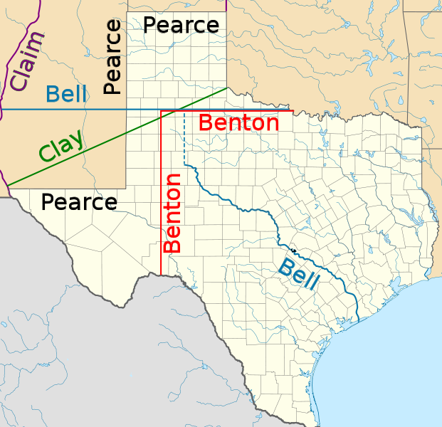
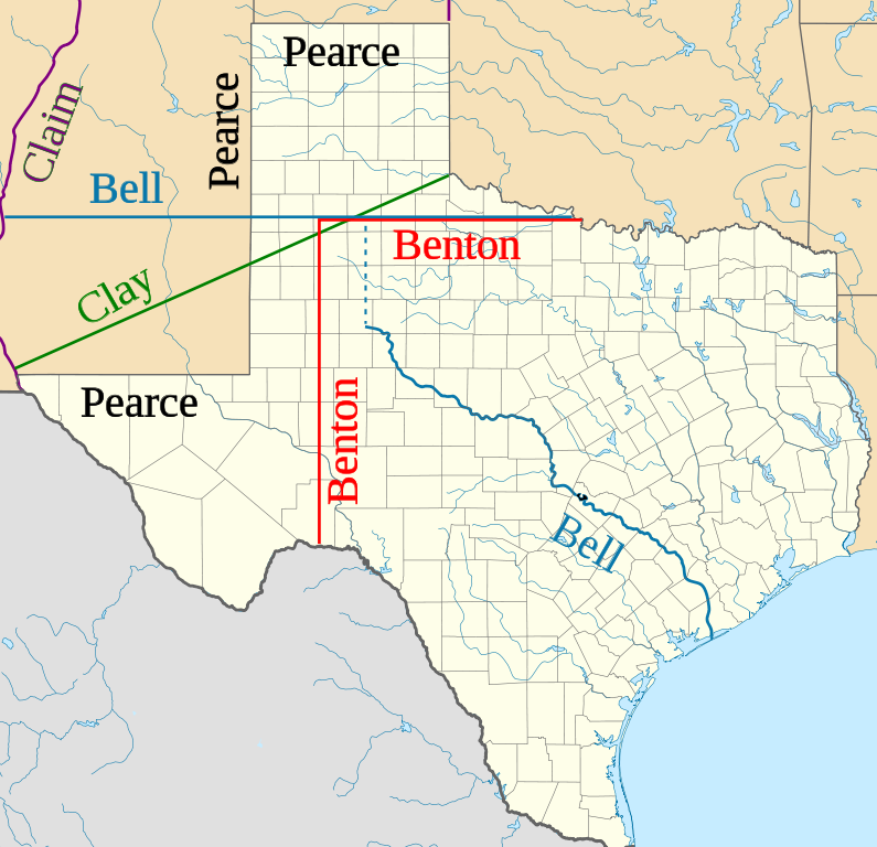
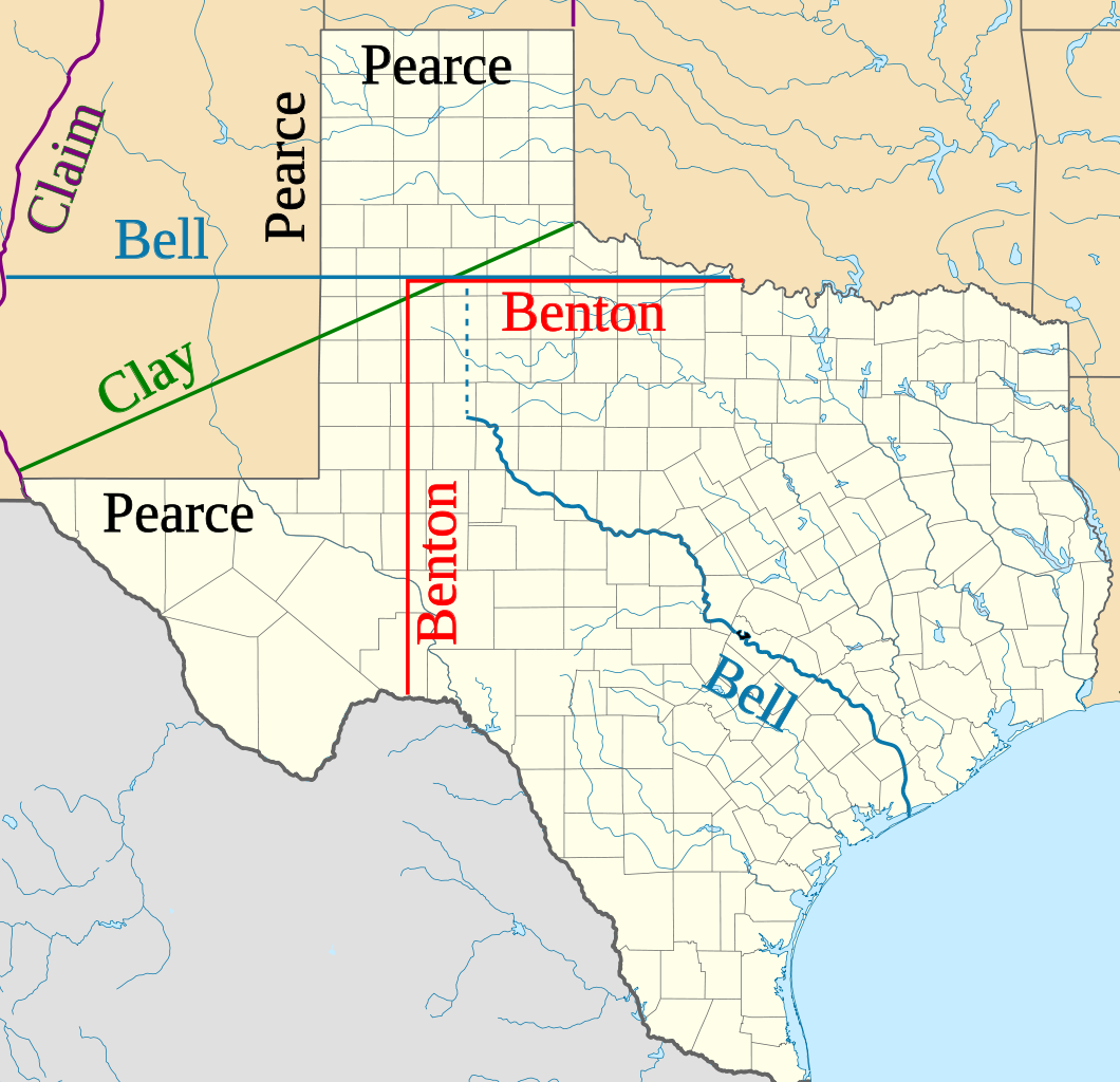
| Beskrywing | Northern and western boundaries of Texas proposed by various Senators in the Compromise of 1850 debate |
| Datum | (UTC) |
| Bron | |
| Outeur |
|
| This is a retouched picture, which means that it has been digitally altered from its original version. Modifications: Proposed boundaries for Compromise of 1850. The original can be viewed here: USA Texas location map.svg:
|
Ek, die outeursreghouer van hierdie werk, publiseer dit onder die volgende lisensie:
This file is licensed under the Creative Commons Attribution 3.0 Unported license.
- U is vry:
- om te deel – die werk kopieer, versprei en deurgee
- om te hermeng – om die werk aan te pas
- Onder die volgende voorwaardes:
- naamsvermelding – U moet die nodige krediet gee, 'n skakel na die lisensie verskaf en aandui of daar veranderinge aangebring is. U mag dit op enige redelike manier doen, maar nie op enige manier wat daarop dui dat die lisensiegewer u of u gebruik onderskryf nie.

|
Toestemming word verleen tot die kopiëring, verspreiding en/of wysiging van hierdie dokument onder die voorwaardes van die GNU-lisensie vir vrye dokumentasie, weergawe 1.2 of enige latere weergawe uitgegee deur die Stigting vir Vrye Sagteware, sonder Invariante Dele, geen Voorbladtekste en geen Agterbladtekste. 'n Kopie van hierdie lisensie is ingesluit in die afdeling getiteld GNU Free Documentation License. |
U kan die lisensie van u keuse kies.
Oorspronklike oplaailogboek
This image is a derivative work of the following images:
- File:USA_Texas_location_map.svg licensed with Cc-by-3.0, GFDL
- 2009-06-17T20:30:36Z Alexrk2 1500x1484 (711918 Bytes) enh
- 2009-06-07T13:05:09Z Alexrk 1500x1484 (571429 Bytes) water bodies 1:10mio
- 2009-06-06T21:43:21Z Alexrk 1500x1484 (870861 Bytes) GeneralizationDistance = 2px
- 2009-06-06T17:41:11Z Alexrk 1500x1485 (1550930 Bytes) == Beschreibung == {{Information |Description= {{de|Positionskarte von [[:de:Texas|Texas]], [[:de:USA|USA]]}} Quadratische Plattkarte, N-S-Streckung 120 %. Geographische Begrenzung der Karte: * N: 36.8° N * S: 25.5° N * W:
Uploaded with derivativeFX
Lêergeskiedenis
Klik op die datum/tyd om te sien hoe die lêer destyds gelyk het.
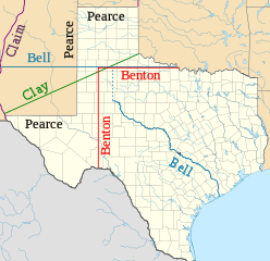
| Datum/Tyd | Duimnael | Dimensies | Gebruiker | Opmerking | |
|---|---|---|---|---|---|
| huidig | 00:11, 29 Januarie 2010 | | 1 475 × 1 425 (697 KG) | JWB | Identify more of Pearce and Benton lines |
| 00:03, 29 Januarie 2010 |  | 1 475 × 1 425 (696 KG) | JWB | Identify final proposal as Pearce's | |
| 23:52, 28 Januarie 2010 |  | 1 475 × 1 425 (696 KG) | JWB | Tweaks | |
| 23:50, 28 Januarie 2010 |  | 1 475 × 1 400 (696 KG) | JWB | {{Information |Description=Northern and western boundaries of Texas proposed by various Senators in the Compromise of 1850 debate |Source=*File:USA_Texas_location_map.svg |Date=2010-01-28 23:47 (UTC) |Author=*File:USA_Texas_location_map.svg: [ |
Lêergebruik
Die volgende bladsy gebruik dié lêer:
Globale lêergebruik
Die volgende ander wiki's gebruik hierdie lêer:
- Gebruik in azb.wikipedia.org
- Gebruik in cy.wikipedia.org
- Gebruik in en.wikipedia.org
- Gebruik in fy.wikipedia.org
- Gebruik in id.wikipedia.org
- Gebruik in it.wikipedia.org
- Gebruik in ja.wikipedia.org
- Gebruik in kk.wikipedia.org
- Gebruik in mk.wikipedia.org
- Gebruik in ms.wikipedia.org
- Gebruik in pt.wikipedia.org
- Gebruik in ro.wikipedia.org
- Gebruik in ru.wikipedia.org
- Gebruik in th.wikipedia.org
- Gebruik in uz.wikipedia.org
- Gebruik in vi.wikipedia.org
- Gebruik in www.wikidata.org