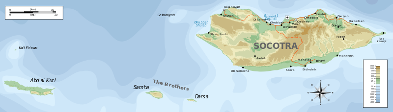
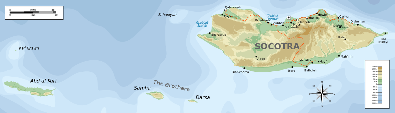
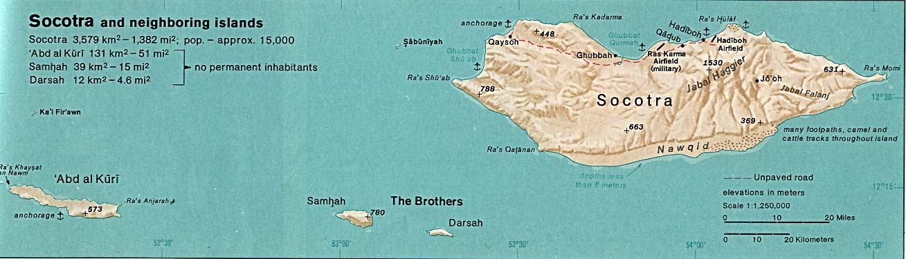
Lêer:Topographic map of Socotra-en.svg

Size of this PNG preview of this SVG file: 800 × 229 piksels. Ander resolusies: 320 × 92 piksels | 640 × 183 piksels | 1 024 × 293 piksels | 1 280 × 367 piksels | 2 560 × 733 piksels | 1 309 × 375 piksels.
Oorspronklike lêer (SVG-lêer, normaalweg 1 309 × 375 piksels, lêergrootte: 572 KG)
Opsomming
| Beskrywing |
English: Topographic map of Socotra.
Deutsch: Topographische Karte von Sokotra.
Français : Carte topographique de Socotra.
Македонски: Топографска карта на Сокотра.
Suomi: Sokotran topografinen kartta.
Русский: Топографическая карта Сокотры |
| Datum | |
| Bron |
Self-made in Inkscape. |
| Outeur | Oona Räisänen (Mysid) |
| Ander weergawes |
Derivative works of this file: |

|
This SVG file contains embedded text that can be translated into your language, using any capable SVG editor, text editor or the SVG Translate tool. For more information see: About translating SVG files. |
Lisensiëring
Ek, die outeursreghouer van hierdie werk, publiseer dit onder die volgende lisensie:

|
Toestemming word verleen tot die kopiëring, verspreiding en/of wysiging van hierdie dokument onder die voorwaardes van die GNU-lisensie vir vrye dokumentasie, weergawe 1.2 of enige latere weergawe uitgegee deur die Stigting vir Vrye Sagteware, sonder Invariante Dele, geen Voorbladtekste en geen Agterbladtekste. 'n Kopie van hierdie lisensie is ingesluit in die afdeling getiteld GNU Free Documentation License. |
This file is licensed under the Creative Commons Attribution-Share Alike Attribution-Share Alike 4.0 International, 3.0 Unported, 2.5 Generic, 2.0 Generic and 1.0 Generic license.
- U is vry:
- om te deel – die werk kopieer, versprei en deurgee
- om te hermeng – om die werk aan te pas
- Onder die volgende voorwaardes:
- naamsvermelding – U moet die nodige krediet gee, 'n skakel na die lisensie verskaf en aandui of daar veranderinge aangebring is. U mag dit op enige redelike manier doen, maar nie op enige manier wat daarop dui dat die lisensiegewer u of u gebruik onderskryf nie.
- insgelyks – As u die materiaal hermix, transformeer of voortbou, moet u u bydraes versprei onder die dieselfde of versoenbare lisensie as die oorspronklike.
U kan die lisensie van u keuse kies.
Lêergeskiedenis
Klik op die datum/tyd om te sien hoe die lêer destyds gelyk het.
| Datum/Tyd | Duimnael | Dimensies | Gebruiker | Opmerking | |
|---|---|---|---|---|---|
| huidig | 19:08, 29 Junie 2010 | 1 309 × 375 (572 KG) | Mysid | removing buggy shading | |
| 19:05, 29 Junie 2010 | 1 309 × 375 (1,13 MG) | Mysid | update | ||
| 22:24, 19 Mei 2008 | 1 309 × 375 (229 KG) | Mysid | bugfix #1 | ||
| 22:23, 19 Mei 2008 | 1 309 × 375 (229 KG) | Mysid | == {{int:filedesc}} == {{Information |Description= {{en|Topographic map of en:Socotra.}} {{fr|Carte topographique du fr:Socotra.}} {{fi|fi:Sokotran topografinen kartta.}} |Source=Self-made in Inkscape.<br/>Boundaries, roads, and place na |
Lêergebruik
Die volgende bladsy gebruik dié lêer:
Globale lêergebruik
Die volgende ander wiki's gebruik hierdie lêer:
- Gebruik in ar.wikipedia.org
- Gebruik in az.wikipedia.org
- Gebruik in bg.wikipedia.org
- Gebruik in bn.wikipedia.org
- Gebruik in bs.wikipedia.org
- Gebruik in ca.wikipedia.org
- Gebruik in ckb.wikipedia.org
- Gebruik in cs.wikipedia.org
- Gebruik in cy.wikipedia.org
- Gebruik in da.wikipedia.org
- Gebruik in de.wikipedia.org
- Gebruik in en.wikipedia.org
- Gebruik in et.wikipedia.org
- Gebruik in fi.wikipedia.org
- Gebruik in fr.wikipedia.org
- Gebruik in gl.wikipedia.org
- Gebruik in he.wikipedia.org
- Gebruik in hr.wikipedia.org
- Gebruik in hu.wikipedia.org
- Gebruik in is.wikipedia.org
- Gebruik in it.wikipedia.org
- Gebruik in ja.wikipedia.org
- Gebruik in ka.wikipedia.org
- Gebruik in lt.wikipedia.org
- Gebruik in ms.wikipedia.org
- Gebruik in nl.wikipedia.org
- Gebruik in nn.wikipedia.org
Wys meer globale gebruik van die lêer.