Lêer:TristanDaCunha.jpg

Geen hoër resolusie is beskikbaar nie.
TristanDaCunha.jpg (440 × 340 piksels, lêergrootte: 3 KG, MIME-tipe: image/jpeg)
Opsomming
| Beskrywing |
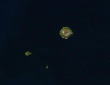
Satellite picture of the Tristan da Cunha Islands, South Atlantic Ocean Deutsch: Satellitenaufnahme von Tristan da Cunha
Español: El archipiélago en una imagen obtenida por un satélite.
Suomi: Satelliittikuva saarista
Français : Vue satellite de l'archipel. L'île de Tristan da Cunha est la plus grande île. À sa gauche se situent de haut en bas l'île Inaccessible et l'île Nightingale
Italiano: Tristan da Cunha e isole circostanti(immagine da satellite)
Polski: Zdjęcie satelitarne archipelagu
Русский: Вид архипелага из космоса (кроме острова Гоф) |
| Datum | |
| Bron | http://eoimages.gsfc.nasa.gov/images/imagerecords/69000/69741/TristanDaCunha.A2003354.1500.250m.jpg |
| Outeur | Image courtesy of MODIS Rapid Response Project at NASA/GSFC |
| Toestemming (Hergebruik van die lêer) |
http://visibleearth.nasa.gov/useterms.php |
Lisensiëring
| This file is in the public domain in the United States because it was solely created by NASA. NASA copyright policy states that "NASA material is not protected by copyright unless noted". (See Template:PD-USGov, NASA copyright policy page or JPL Image Use Policy.) | ||
 |
Warnings:
|
| Annotations | This image is annotated: View the annotations at Commons |
Lêergeskiedenis
Klik op die datum/tyd om te sien hoe die lêer destyds gelyk het.
| Datum/Tyd | Duimnael | Dimensies | Gebruiker | Opmerking | |
|---|---|---|---|---|---|
| huidig | 07:43, 4 Januarie 2005 | | 440 × 340 (3 KG) | Veinsworld | Tristan da Cunha |
Lêergebruik
Die volgende bladsy gebruik dié lêer:
Globale lêergebruik
Die volgende ander wiki's gebruik hierdie lêer:
- Gebruik in an.wikipedia.org
- Gebruik in arz.wikipedia.org
- Gebruik in ast.wikipedia.org
- Gebruik in br.wikipedia.org
- Gebruik in ca.wikipedia.org
- Gebruik in ceb.wikipedia.org
- Gebruik in cy.wikipedia.org
- Gebruik in de.wikipedia.org
- Gebruik in de.wikivoyage.org
- Gebruik in en.wikipedia.org
- Gebruik in eo.wikipedia.org
- Gebruik in es.wikipedia.org
- Gebruik in fi.wikipedia.org
- Gebruik in fi.wiktionary.org
- Gebruik in fr.wikipedia.org
- Gebruik in fr.wikivoyage.org
- Gebruik in gl.wikipedia.org
- Gebruik in hr.wikipedia.org
- Gebruik in ig.wikipedia.org
- Gebruik in it.wikipedia.org
- Gebruik in ka.wikipedia.org
- Gebruik in no.wikipedia.org
- Gebruik in oc.wikipedia.org
- Gebruik in pap.wikipedia.org
- Gebruik in pl.wikipedia.org
- Gebruik in pt.wikipedia.org
- Gebruik in ru.wikipedia.org
- Gebruik in simple.wikipedia.org
- Gebruik in tl.wikipedia.org
- Gebruik in vec.wikipedia.org
- Gebruik in www.wikidata.org