Lêer:1759 map Holy Land and 12 Tribes.jpg

Oorspronklike lêer(2 000 × 1 676 piksels, lêergrootte: 1,74 MG, MIME-tipe: image/jpeg)

Hierdie lêer kom vanaf Wikimedia Commons en kan ook in ander projekte gebruik word. Die beskrywing op die lêer se inligtingsblad word hieronder weergegee.

Opsomming

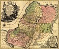
Tobias Conrad Lotter: Latina: Terra Sancta sive Palæstina exhibens no ſolum Regna vetera Iuda et Israel in ſuas XII Tribus diſtincta, ſed etiam eorundem diverſarum ætatum conditionem et facta in Sacris Paginis indicata.   (Wikidata search (Cirrus search) Wikidata query (SPARQL)  Create new Wikidata item based on this file)
Kunstenaar/Skepper
Tobias Conrad Lotter  (1717–1777)  wikidata:Q106511
 
Alternatiewe name
Lotter, Tobias Conrad / Lotter, Tobias Konrad
Beskrywing copper engraver, cartographer en publisher
Geboorte- en sterfdatum 1717 Edit this at Wikidata 1777 Edit this at Wikidata
Geboorte- en sterfplek Augsburg Augsburg
Werksplek
Gesagsbeheer
artist QS:P170,Q106511
Titel
Latina: Terra Sancta sive Palæstina exhibens no ſolum Regna vetera Iuda et Israel in ſuas XII Tribus diſtincta, ſed etiam eorundem diverſarum ætatum conditionem et facta in Sacris Paginis indicata.
Beskrywing
English: English Translation: The Holy Land or Palestine showing not only the Old Kingdoms of Judea and Israel but also the 12 Tribes Distinctly, Confirming their Locations Diversely in their Ancient Condition and Doing So as the Holy Scriptures Indicate.
Datum 1759
date QS:P571,+1759-00-00T00:00:00Z/9
Tegniek handgekleurd
Dimensies Hoogte: 47 cm; breedte: 57 cm
dimensions QS:P2048,47U174728
dimensions QS:P2049,57U174728
Library of Congress Geography and Map Division Washington, D.C. 20540-4650
Opmerkings Scale [ca. 1:695,000]
Bron/Fotograaf Geography and Map Division, Library of Congress
Ander weergawes

Lisensiëring

This is a faithful photographic reproduction of a two-dimensional, public domain work of art. The work of art itself is in the public domain for the following reason:
Public domain

This work is in the public domain in its country of origin and other countries and areas where the copyright term is the author's life plus 100 years or fewer.


You must also include a United States public domain tag to indicate why this work is in the public domain in the United States.
The official position taken by the Wikimedia Foundation is that "faithful reproductions of two-dimensional public domain works of art are public domain".
This photographic reproduction is therefore also considered to be in the public domain in the United States. In other jurisdictions, re-use of this content may be restricted; see Reuse of PD-Art photographs for details.

Captions

Add a one-line explanation of what this file represents

Items portrayed in this file

uitbeelding

MIME type Engels

image/jpeg

checksum Engels

9aec441e2a748bb1f14eca6e42dd7d08ce2e766b

data size Engels

1 827 878 greep

height Engels

1 676 pieksel

width Engels

2 000 pieksel

Lêergeskiedenis

Klik op die datum/tyd om te sien hoe die lêer destyds gelyk het.

Datum/TydDuimnaelDimensiesGebruikerOpmerking
huidig10:43, 12 September 2005Duimnaelskets vir weergawe vanaf 10:43, 12 September 20052 000 × 1 676 (1,74 MG)Humus sapiens~commonswiki1759 map: Terra Sancta sive Palæstina exhibens no folum Regna vetera Iuda et Israel in fuas XII Tribus diftincta... Source: Library of Congress historical maps Category:Historical maps of the Middle East Category:Israel

Die volgende bladsy gebruik dié lêer:

Globale lêergebruik

Die volgende ander wiki's gebruik hierdie lêer:

Wys meer globale gebruik van die lêer.