Lêer:Adygea districts.png

Grootte van hierdie voorskou: 785 × 600 piksels. Ander resolusies: 314 × 240 piksels | 628 × 480 piksels | 1 013 × 774 piksels.
Oorspronklike lêer (1 013 × 774 piksels, lêergrootte: 56 KG, MIME-tipe: image/png)
Opsomming
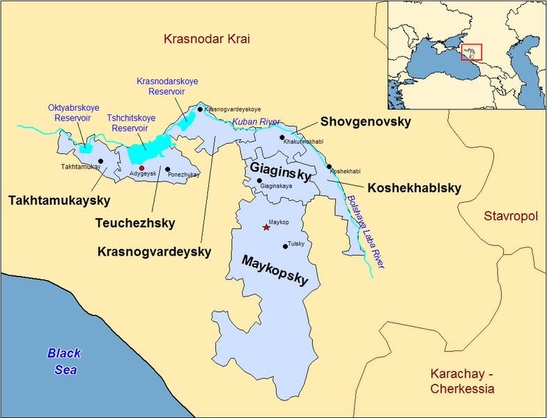
| Beskrywing | Map of the districts of the Adygea republic of Russia. Created by Rarelibra 13:10, 30 March 2007 (UTC) for public domain use, using MapInfo Professional v8.5 and various mapping resources. |
| Datum | 30 Maart 2007 (original upload date) |
| Bron | Geen machineleesbare bron opgegeven. Eigen werk aangenomen (gebaseerd op auteursrechtclaims). |
| Outeur | Geen machineleesbare auteur aanwezig. Op basis van auteursrechtclaims wordt auteur Rarelibra aangenomen. |
Previous summary and history (en.wikipedia)
Map of the districts of the Republic of Adygea (federal subject of Russia). Created by Rarelibra 20:52, 20 December 2006 (UTC) for public domain use, using MapInfo Professional v8.5 and various mapping resources. Special thanks to w:User:Ezhiki for both his patience and input to help complete this map for his wiki project.
- 16:06, April 3, 2007 . . Rarelibra (Talk | contribs | block) . . 1056×816 (58,397 bytes) (Updated version)
- 17:35, March 27, 2007 . . Rarelibra (Talk | contribs | block) . . 823×752 (50,852 bytes) (Updated map)
- 22:34, December 20, 2006 . . Rarelibra (Talk | contribs | block) . . 1281×878 (48,913 bytes) (Map of the districts of the Republic of Adygea (a federal subject of Russia). Created by ~~~~ for public domain use with attribution under GNU. Created using MapInfo Professional v8.5 and various mapping resources. Special thanks to User:Ezhiki for hi)
- 20:52, December 20, 2006 . . Rarelibra (Talk | contribs | block) . . 1281×878 (43,557 bytes) (Map of the districts of the Republic of Adygea (federal subject of Russia). Created by ~~~~ for public domain use, using MapInfo Professional v8.5 and various mapping resources. Special thanks to User:Ezhiki for both his patience and input to help com)
Lisensiëring
| Ek, die outeursreghouer van hierdie werk, stel dit hiermee in die publieke domein vry. Dit geld wêreldwyd. In sommige lande is dit dalk nie wettiglik moontlik nie. Indien so: Ek verleen aan enigiemand die reg om hierdie werk te gebruik vir enige doel, sonder voorwaardes, tensy sulke voorwaardes deur die wet vereis word. |
Lêergeskiedenis
Klik op die datum/tyd om te sien hoe die lêer destyds gelyk het.
| Datum/Tyd | Duimnael | Dimensies | Gebruiker | Opmerking | |
|---|---|---|---|---|---|
| huidig | 22:53, 31 Desember 2023 | | 1 013 × 774 (56 KG) | User-duck | Cropped border using CropTool with lossless mode. |
| 13:18, 23 April 2007 |  | 1 056 × 816 (57 KG) | Rarelibra | Reverted to earlier revision | |
| 15:54, 21 April 2007 |  | 1 056 × 816 (46 KG) | David Kernow~commonswiki | ||
| 16:04, 3 April 2007 |  | 1 056 × 816 (57 KG) | Rarelibra | Updated version | |
| 13:10, 30 Maart 2007 |  | 823 × 752 (50 KG) | Rarelibra | Map of the districts of the Adygea republic of Russia. Created by ~~~~ for public domain use, using MapInfo Professional v8.5 and various mapping resources. |
Lêergebruik
Die volgende bladsy gebruik dié lêer:
Globale lêergebruik
Die volgende ander wiki's gebruik hierdie lêer:
- Gebruik in azb.wikipedia.org
- Gebruik in ca.wikipedia.org
- Gebruik in cy.wikipedia.org
- Gebruik in de.wikipedia.org
- Gebruik in el.wikipedia.org
- Gebruik in en.wikipedia.org
- Gebruik in fa.wikipedia.org
- Gebruik in fi.wikipedia.org
- Gebruik in frr.wikipedia.org
- Gebruik in fr.wikipedia.org
- Gebruik in incubator.wikimedia.org
- Gebruik in io.wikipedia.org
- Gebruik in it.wikipedia.org
- Gebruik in krc.wikipedia.org
- Gebruik in lv.wikipedia.org
- Gebruik in mn.wikipedia.org
- Gebruik in nl.wikipedia.org
- Gebruik in pl.wikipedia.org
- Gebruik in pl.wiktionary.org
- Gebruik in pt.wikipedia.org
- Gebruik in ru.wikivoyage.org