Oorspronklike lêer(5 500 × 4 589 piksels, lêergrootte: 5,94 MG, MIME-tipe: image/jpeg)

Hierdie lêer kom vanaf Wikimedia Commons en kan ook in ander projekte gebruik word. Die beskrywing op die lêer se inligtingsblad word hieronder weergegee.

Opsomming

wikidata:Q15726418
Naam van werk
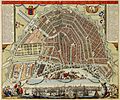
Latina: EXACTISSIMA AMSTELODAMI VETERIS ET NOVISSIMA DELINEATO PER F. DE WIT
Datum circa 1688
date QS:P,+1688-00-00T00:00:00Z/9,P1480,Q5727902
Bron

http://resolver.kb.nl/resolve?urn=urn:gvn:KONB01:1049B11_091&size=large (kopergravure, prent ), Atlas Van der Hagen, Koninklijke Bibliotheek, Den Haag. Source page at the Geheugen van Nederland / Memory of the Netherlands website

Skepper
Frederik de Wit  (1630–1706)  wikidata:Q1402952
 
Alternatiewe name
Frederic, Frederik, Frederico, Fredericus; de Witt, de Widt.
Beskrywing Dutch kartograaf, printmaker en copper engraver
Geboorte- en sterfdatum circa  Edit this at Wikidata 1706 Edit this at Wikidata
Geboorte- en sterfplek Gouda Amsterdam
Werk periode 17 century
date QS:P,+1650-00-00T00:00:00Z/7
 Edit this at Wikidata
Werksplek
Gesagsbeheer
creator QS:P170,Q1402952
Toestemming
(Hergebruik van die lêer)
This is a faithful photographic reproduction of a two-dimensional, public domain work of art. The work of art itself is in the public domain for the following reason:
Public domain

This work is in the public domain in its country of origin and other countries and areas where the copyright term is the author's life plus 100 years or fewer.


You must also include a United States public domain tag to indicate why this work is in the public domain in the United States.
The official position taken by the Wikimedia Foundation is that "faithful reproductions of two-dimensional public domain works of art are public domain".
This photographic reproduction is therefore also considered to be in the public domain in the United States. In other jurisdictions, re-use of this content may be restricted; see Reuse of PD-Art photographs for details.
 Geotemporal data
Date depicted circa 1688
date QS:P,+1688-00-00T00:00:00Z/9,P1480,Q5727902
Map location Amsterdam
Georeferencing Georeference the map in Wikimaps Warper If inappropriate please set warp_status = skip to hide.
 Bibliographic data
Reeks Atlas Van der Hagen, Koninklijke Bibliotheek, Den Haag
 Archival data
institution QS:P195,Q1526131
Tegniek kopergravure
Ander weergawes
Error in {{Map}} template: unknown parameter "wikidata".

Captions

Add a one-line explanation of what this file represents

MIME type Engels

image/jpeg

checksum Engels

bc6819be4529914a3b3f1aee1d0f913d81c1088f

data size Engels

6 232 823 greep

height Engels

4 589 pieksel

width Engels

5 500 pieksel

Lêergeskiedenis

Klik op die datum/tyd om te sien hoe die lêer destyds gelyk het.

Datum/TydDuimnaelDimensiesGebruikerOpmerking
huidig11:04, 29 September 2011Duimnaelskets vir weergawe vanaf 11:04, 29 September 20115 500 × 4 589 (5,94 MG)Fentener van Vlissingen{{Information |Description=EXACTISSIMA AMSTELODAMI VETERIS ET NOVISSIMA DELINEATO PER F. DE WIT |Source=[http://www.geheugenvannederland.nl/?/nl/items/KONB01:229 Atlas Van der Hagen, Koninklijke Bibliotheek, Den Haag] |Date=after 1688 |Author=Frederick de

Daar is geen bladsye wat dié lêer gebruik nie.

Globale lêergebruik

Metadata