Lêer:Baton Rouge Louisiana waterfront aerial view.jpg
Grootte van hierdie voorskou: 750 × 600 piksels. Ander resolusies: 300 × 240 piksels | 600 × 480 piksels | 960 × 768 piksels | 1 280 × 1 024 piksels | 1 500 × 1 200 piksels.
Oorspronklike lêer (1 500 × 1 200 piksels, lêergrootte: 1,04 MG, MIME-tipe: image/jpeg)
| Beskrywing |
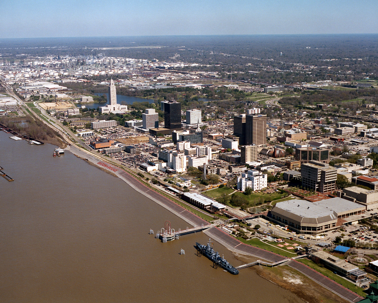
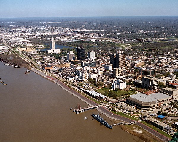
English: Aerial view of the riverfront area of Baton Rouge, Louisiana, USA. The city fronts on the Mississippi River in the center of Louisiana. The tall state capitol tower can be seen at center left. The historic destroyer USS Kidd is moored in the river at the bottom of the picture. View is to the north-northeast. |
|||
| Datum | ||||
| Bron |
U.S. Army Corps of Engineers Digital Visual Library Image page Image description page Digital Visual Library home page |
|||
| Outeur | Michael Maples, U.S. Army Corps of Engineers | |||
| Toestemming (Hergebruik van die lêer) |
|
|||
| Location | Baton Rouge, Louisiana, USA |
| Kameraligging | | Hierdie en ander beelde in: OpenStreetMap |
|---|
Lêergeskiedenis
Klik op die datum/tyd om te sien hoe die lêer destyds gelyk het.
| Datum/Tyd | Duimnael | Dimensies | Gebruiker | Opmerking | |
|---|---|---|---|---|---|
| huidig | 03:05, 6 April 2007 | | 1 500 × 1 200 (1,04 MG) | DanMS | {{Information | Description = {{en|Aerial view of the riverfront area of Baton Rouge, Louisiana, USA. The ctiy fronts on the Mississippi River in the center of Louisiana. The tall state capital tower can be seen at center left. The historic destroyer U |
Lêergebruik
Die volgende bladsy gebruik dié lêer:
Globale lêergebruik
Die volgende ander wiki's gebruik hierdie lêer:
- Gebruik in an.wikipedia.org
- Gebruik in ar.wikipedia.org
- Gebruik in arz.wikipedia.org
- Gebruik in ast.wikipedia.org
- Gebruik in az.wikipedia.org
- Gebruik in bat-smg.wikipedia.org
- Gebruik in be-tarask.wikipedia.org
- Gebruik in be.wikipedia.org
- Gebruik in bg.wikipedia.org
- Gebruik in br.wikipedia.org
- Gebruik in ca.wikipedia.org
- Gebruik in ceb.wikipedia.org
- Gebruik in ce.wikipedia.org
- Gebruik in cy.wikipedia.org
- Gebruik in dag.wikipedia.org
- Gebruik in da.wikipedia.org
- Gebruik in de.wikipedia.org
- Gebruik in de.wikivoyage.org
- Gebruik in diq.wikipedia.org
- Gebruik in el.wikipedia.org
- Gebruik in en.wikipedia.org
- Gebruik in en.wikinews.org
- Gebruik in en.wikivoyage.org
- Gebruik in en.wiktionary.org
- Gebruik in es.wikipedia.org
- Gebruik in et.wikipedia.org
- Gebruik in eu.wikipedia.org
- Gebruik in fi.wikipedia.org
- Gebruik in fr.wikipedia.org
- Gebruik in fr.wikivoyage.org
- Gebruik in fy.wikipedia.org
- Gebruik in ga.wikipedia.org
- Gebruik in gl.wikipedia.org
- Gebruik in he.wikipedia.org
- Gebruik in he.wikivoyage.org
- Gebruik in hsb.wikipedia.org
- Gebruik in ht.wikipedia.org
- Gebruik in hu.wikipedia.org
Wys meer globale gebruik van die lêer.