Lêer:Bcamazonica.jpg
Geen hoër resolusie is beskikbaar nie.
Bcamazonica.jpg (800 × 578 piksels, lêergrootte: 260 KG, MIME-tipe: image/jpeg)

|
This map image could be re-created using vector graphics as an SVG file. This has several advantages; see Commons:Media for cleanup for more information. If an SVG form of this image is available, please upload it and afterwards replace this template with
{{vector version available|new image name}}.
It is recommended to name the SVG file “Bcamazonica.svg”—then the template Vector version available (or Vva) does not need the new image name parameter. |


| Beskrywing |
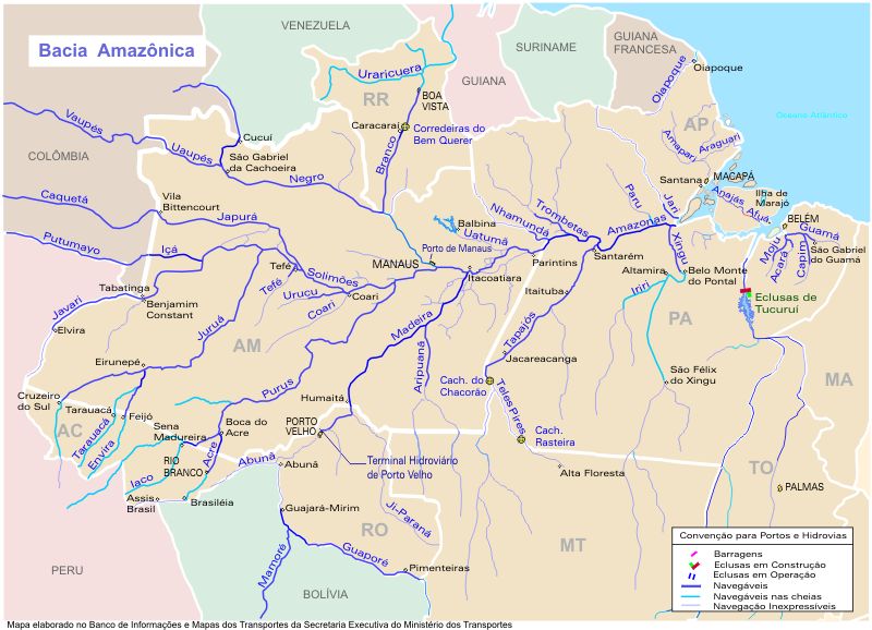
Português: O mapa mostra a região hidrográfica do Amazonas
English: Map showing the Amazonas watershed |
|||
| Bron | https://web.archive.org/web/20090620080103/http://www.transportes.gov.br/bit/mapas/mapclick/hidro/bcamaz.htm | |||
| Outeur | Secretaria Executiva do Ministério dos Transportes | |||
| Toestemming (Hergebruik van die lêer) |
|
|||
| Ander weergawes |
|


Lêergeskiedenis
Klik op die datum/tyd om te sien hoe die lêer destyds gelyk het.
| Datum/Tyd | Duimnael | Dimensies | Gebruiker | Opmerking | |
|---|---|---|---|---|---|
| huidig | 18:19, 18 April 2005 | | 800 × 578 (260 KG) | Santana-freitas~commonswiki | Região Hidrográfica do Amazonas |
Lêergebruik
Die volgende bladsy gebruik dié lêer:
Globale lêergebruik
Die volgende ander wiki's gebruik hierdie lêer:
- Gebruik in ar.wikipedia.org
- Gebruik in arz.wikipedia.org
- Gebruik in azb.wikipedia.org
- Gebruik in be.wikipedia.org
- Gebruik in br.wikipedia.org
- Gebruik in ca.wikipedia.org
- Gebruik in ceb.wikipedia.org
- Gebruik in de.wikipedia.org
- Gebruik in en.wikipedia.org
- Gebruik in es.wikipedia.org
- Usuaria:Rociovalencia
- Usuaria:Rocio Valencia Felipe
- Río Vaupés
- Río Tacutu
- Wikipedia:¿Sabías que.../enero de 2008
- Wikipedia:¿Sabías que.../4 de enero de 2008
- Usuario:Leandro10 3
- Usuario:Zero spartan
- Wikipedia:¿Sabías que.../1
- Wikipedia:¿Sabías que.../2
- Usuario:Alvaro qc
- Usuario:Alvaro qc/página de usuario.css
- Usuario:Alvaro qc/Portada/2.0
- Usuario:Alvaro qc/Portada/2.1
- Usuario:Alvaro qc/Portada/2.2
- Usuario:ElBeTa
Wys meer globale gebruik van die lêer.