Lêer:Brit IndianEmpireReligions3.jpg

Grootte van hierdie voorskou: 741 × 599 piksels. Ander resolusies: 297 × 240 piksels | 593 × 480 piksels | 949 × 768 piksels | 1 266 × 1 024 piksels | 1 534 × 1 241 piksels.
Oorspronklike lêer (1 534 × 1 241 piksels, lêergrootte: 2,33 MG, MIME-tipe: image/jpeg)
Opsomming
| Beskrywing |
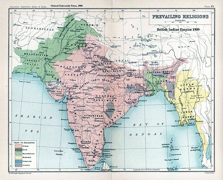
English: Map "Prevailing Religions of the British Indian Empire, 1909" Key:
|
| Datum | |
| Bron | The Imperial Gazetteer of India, Oxford University Press, 1909. Scanned from personal copy and annotated by me (Fowler&fowler«Talk» 04:16, 19 March 2007 (UTC)) |
| Outeur |
English: John George Bartholomew |
| Ander weergawes |
.jpg)


|
This old map image could be re-created using vector graphics as an SVG file. This has several advantages; see Commons:Media for cleanup for more information. If an SVG form of this image is available, please upload it and afterwards replace this template with
{{vector version available|new image name}}.
It is recommended to name the SVG file “Brit IndianEmpireReligions3.svg”—then the template Vector version available (or Vva) does not need the new image name parameter. |


Lisensiëring
|
The author died in 1920, so this work is in the public domain in its country of origin and other countries and areas where the copyright term is the author's life plus 100 years or fewer. This work is in the public domain in the United States because it was published (or registered with the U.S. Copyright Office) before January 1, 1929. | |
| Hierdie lêer is geïdentifiseer as vry van bekende beperkings onder kopiereg, insluitend alle verwante en naburige regte. | |
Oorspronklike oplaailogboek
The original description page was here. All following user names refer to en.wikipedia.
- 2007-03-19 04:16 Fowler&fowler 1650×1275×8 (338398 bytes) Map "Prevailing Religions of the British Indian Empire, 1909" from the Imperial Gazetteer of India, Oxford University Press, 1909. Scanned from personal copy and annotated by me (~~~~) {{PD-old-75}}
| Annotations | This image is annotated: View the annotations at Commons |
Lêergeskiedenis
Klik op die datum/tyd om te sien hoe die lêer destyds gelyk het.
| Datum/Tyd | Duimnael | Dimensies | Gebruiker | Opmerking | |
|---|---|---|---|---|---|
| huidig | 02:39, 18 Januarie 2019 | | 1 534 × 1 241 (2,33 MG) | Frank Klemm | Cropped, white balanced |
| 13:27, 29 Desember 2011 |  | 1 504 × 1 232 (2,06 MG) | Maproom | Made colours less washed-out | |
| 01:20, 11 Februarie 2009 |  | 1 504 × 1 232 (311 KG) | AnonMoos | losslessly cropping margins | |
| 03:06, 21 September 2007 |  | 1 650 × 1 275 (330 KG) | Shooke | {{Information |Description=Map "Prevailing Religions of the British Indian Empire, 1909" from the Imperial Gazetteer of India, Oxford University Press, 1909. Scanned from personal copy and annotated by me ([[:en:User:Fowler&fowler|<font color="#B8860B">F |
Lêergebruik
Die volgende bladsy gebruik dié lêer:
Globale lêergebruik
Die volgende ander wiki's gebruik hierdie lêer:
- Gebruik in ar.wikipedia.org
- Gebruik in ast.wikipedia.org
- Gebruik in az.wikipedia.org
- Gebruik in ba.wikipedia.org
- Gebruik in bg.wikipedia.org
- Gebruik in bn.wikipedia.org
- Gebruik in bn.wikiquote.org
- Gebruik in ca.wikipedia.org
- Gebruik in ckb.wikipedia.org
- Gebruik in cs.wikipedia.org
- Gebruik in de.wikipedia.org
- Gebruik in diq.wikipedia.org
- Gebruik in en.wikipedia.org
- History of India
- Kashmir
- Partition of India
- Gazetteer
- History of Hinduism
- Dominion of India
- British Raj
- User:Fowler&fowler
- Talk:History of Pakistan/History of the Pakistan region
- User:Fowler&fowler/Short History Indian Independence Movement
- User:Fowler&fowler/History of Pakistan
- History of the British Raj
- History of East Pakistan
- Talk:Jammu and Kashmir (state)/Archive 1
- User talk:RegentsPark/Archive 4
- User:Fowler&fowler/History of the Pakistan region
- Talk:British Raj/Archive 8
- User:Falcaorib
- User:Կիմա34/sandbox
- Gebruik in es.wikipedia.org
- Gebruik in eu.wikipedia.org
- Gebruik in fa.wikipedia.org
- Gebruik in fr.wikipedia.org
Wys meer globale gebruik van die lêer.