Lêer:Carte de la Guyane françoise et l'isle de Cayenne (Bellin, 1763).jpg

Grootte van hierdie voorskou: 800 × 595 piksels. Ander resolusies: 320 × 238 piksels | 640 × 476 piksels | 1 024 × 762 piksels | 1 267 × 943 piksels.
Oorspronklike lêer (1 267 × 943 piksels, lêergrootte: 1,08 MG, MIME-tipe: image/jpeg)
.jpg)
Opsomming
| Beskrywing |
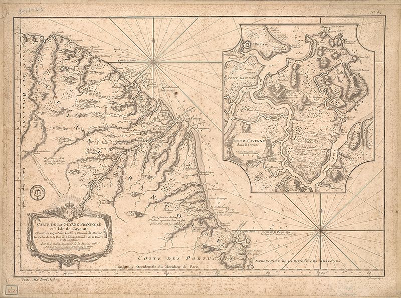
English: This map of French Guiana and the island of Cayenne was made in 1763 by Jacques Bellin (1703-72), a prolific cartographer assigned the Ministry of the French Navy.
Français : Carte de la Guyane françoise et l'isle de Cayenne
Cette carte de la Guyane française et l'île de Cayenne est due à Jacques Bellin (1703-72), un cartographe prolifique affecté au ministère de la Marine française. Elle reflète le soin apporté aux relevés topographiques des baies, des mers et des ports qui caractérisait la cartographie navale française du XVIIIe siècle. En plus d'informations détaillées sur la côte, la carte de Bellin inclut des notes sur l'intérieur de cette partie de l'Amérique du sud, dont l'essentiel restait encore largement inconnu des Européens. |
|||||||||||||||||||
| Datum | , Versailles, France | |||||||||||||||||||
| Bron | Bibliothèque numérique mondiale | |||||||||||||||||||
| Outeur |
|
|||||||||||||||||||
Lisensiëring
|
This work is in the public domain in its country of origin and other countries and areas where the copyright term is the author's life plus 100 years or fewer. | |
| Hierdie lêer is geïdentifiseer as vry van bekende beperkings onder kopiereg, insluitend alle verwante en naburige regte. | |
Lêergeskiedenis
Klik op die datum/tyd om te sien hoe die lêer destyds gelyk het.
| Datum/Tyd | Duimnaelskets | Dimensies | Gebruiker | Opmerking | |
|---|---|---|---|---|---|
| huidig | 23:51, 21 April 2009 | | 1 267 × 943 (1,08 MG) | Abalg | {{Information |Description={{en|1=This map of French Guiana and the island of Cayenne was made in 1763 by Jacques Bellin (1703-72), a prolific cartographer assigned the Ministry of the French Navy.}} {{fr|1=Carte de la Guyane françoise et l'isle de Cayen |
Lêergebruik
Die volgende bladsy gebruik dié lêer:
Globale lêergebruik
Die volgende ander wiki's gebruik hierdie lêer:
- Gebruik in ar.wikipedia.org
- Gebruik in bn.wikipedia.org
- Gebruik in br.wikipedia.org
- Gebruik in en.wikipedia.org
- Gebruik in es.wikipedia.org
- Gebruik in fr.wikipedia.org
- Gebruik in gcr.wikipedia.org
- Gebruik in he.wikipedia.org
- Gebruik in it.wikipedia.org
- Gebruik in pt.wikipedia.org
- Gebruik in ru.wikipedia.org
- Gebruik in sr.wikipedia.org
- Gebruik in vi.wikipedia.org
- Gebruik in www.wikidata.org
.jpg)