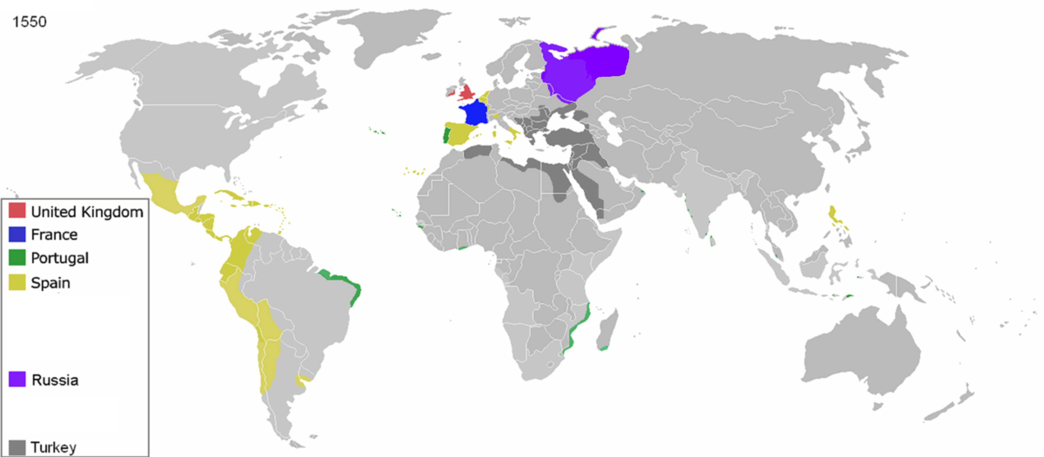
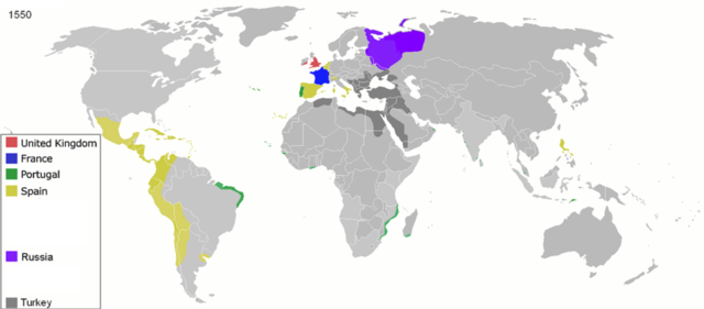
Lêer:Colonisation 1550.png
Oorspronklike lêer (3 600 × 1 578 piksels, lêergrootte: 1,14 MG, MIME-tipe: image/png)
| Beskrywing |
Map of major world powers by year
As the orriginal licence of the animation was Public Domain, this image which has been derived from it is too:
|
||||||||||||||||||
| Datum | |||||||||||||||||||
| Bron | public domain animated map by ArdadN here | ||||||||||||||||||
| Outeur | ArdadN | ||||||||||||||||||
.jpg)
._LOC_2001620596.jpg)

|
This historical map image could be re-created using vector graphics as an SVG file. This has several advantages; see Commons:Media for cleanup for more information. If an SVG form of this image is available, please upload it and afterwards replace this template with
{{vector version available|new image name}}.
It is recommended to name the SVG file “Colonisation 1550.svg”—then the template Vector version available (or Vva) does not need the new image name parameter. |
Lêergeskiedenis
Klik op die datum/tyd om te sien hoe die lêer destyds gelyk het.
| Datum/Tyd | Duimnael | Dimensies | Gebruiker | Opmerking | |
|---|---|---|---|---|---|
| huidig | 11:32, 26 April 2020 | | 3 600 × 1 578 (1,14 MG) | Ориенталист | Clarified the territory of Russia by 1550 |
| 09:25, 5 April 2020 |  | 3 600 × 1 578 (1,14 MG) | Ориенталист | cosmetic changes | |
| 14:55, 27 Maart 2020 |  | 4 275 × 1 875 (1,05 MG) | Ориенталист | Clarified the territory of Russia. | |
| 23:25, 3 Mei 2010 |  | 1 425 × 625 (73 KG) | Kieran4 | Fixed errors. | |
| 10:40, 22 Maart 2007 |  | 1 425 × 625 (65 KG) | Roke~commonswiki | {{Information |Description=Map of major world powers by year {{Maps of world history}} As the orriginal licence of the animation was Public Domain, this image which has been derived from it is too: {{PD-User|Andrei nacu}} |Source=public domain animated m |
Lêergebruik
Die volgende bladsy gebruik dié lêer:
Globale lêergebruik
Die volgende ander wiki's gebruik hierdie lêer:
- Gebruik in ast.wikipedia.org
- Gebruik in bn.wikipedia.org
- Gebruik in bs.wikipedia.org
- Gebruik in cs.wikipedia.org
- Gebruik in de.wikipedia.org
- Gebruik in en.wikipedia.org
- Gebruik in es.wikipedia.org
- Gebruik in fa.wikipedia.org
- Gebruik in fr.wikipedia.org
- Gebruik in he.wikipedia.org
- Gebruik in kk.wikipedia.org
- Gebruik in mg.wikipedia.org
- Gebruik in no.wikipedia.org
- Gebruik in pt.wikipedia.org
- Gebruik in sk.wikipedia.org