Lêer:Grafschaft Mark 1791 Friedrich C Mueller.jpg
Grootte van hierdie voorskou: 677 × 599 piksels. Ander resolusies: 271 × 240 piksels | 542 × 480 piksels | 867 × 768 piksels | 1 157 × 1 024 piksels | 2 033 × 1 800 piksels.
Oorspronklike lêer (2 033 × 1 800 piksels, lêergrootte: 1,32 MG, MIME-tipe: image/jpeg)
|

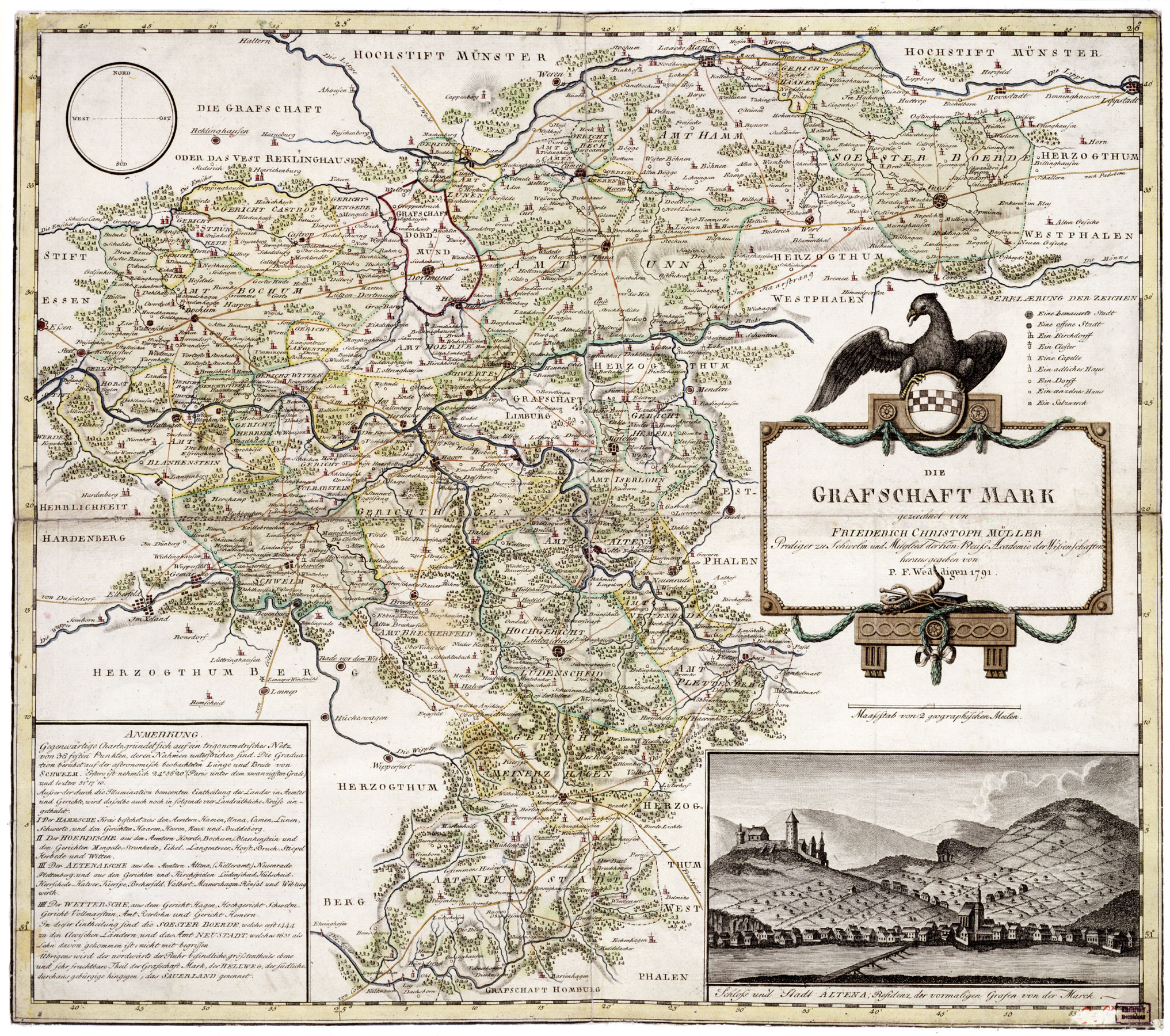
Hierdie beeld is gekies as beeld van die dag op 22 Junie 2007. Die beeld het die volgende beskrywing: Afrikaans: Die graafskap Mark in Duitsland, 1791, deur Friederich Christoph Müller Ander tale:
Afrikaans: Die graafskap Mark in Duitsland, 1791, deur Friederich Christoph Müller Čeština: Mapa zaniklého německého státu Marka Grafschaft Mark z roku 1791 od Friedricha Christopha Müllera. English: Map of County of Mark, Germany, 1791, by Friederich Christoph Müller. Español: Mapa del Condado de Mark, Alemania, 1791, hecho por Friederich Christoph Müller. Esperanto: Mapo de la graflando de Mark, Germanio (1791), de Friederich Christoph Müller. Français : Carte du comté de la Marck, 1791, par Friedrich Christoph Müller. Magyar: A Marki Grófság térképe, Németország, 1791, készítette Friederich Christoph Müller. Nederlands: Kaart van het Duitse Graafschap Mark (Friederich Christoph Müller, 1791) Polski: Mapa hrabstwa Mark, Rzesza Niemiecka (1791). Wykonana przez Friedericha Christopha Müllera Română: Harta comitatului Mark, Germania, 1791, de Friederich Christoph Müller. Slovenčina: Mapa nemeckého panstva Grafschaft Mark z roku 1791 od Friedricha Christopha Müllera. Svenska: Karta över grevskapet Mark i nuvarande Tyskland, ritad av Friederich Christoph Müller, 1791. Беларуская: Карта графства Марка, былой краіны ў Свяшчэннай Рымскай імперыі (Фрыдрых Крыстаф Мюлер, 1791) Русский: Карта графства Марк, Германия (Фридрих Христоф Мюллер, 1791) 中文: 1791年绘制的德国马克县地图。 中文(繁體): 弗里德里希·克里斯托夫·穆勒在1791年繪製的馬克伯爵領地地圖 العربية : خريطة لمقاطعة مارك في ألمانيا في عام 1791 وضعها فريدريك كريستوف مولر. |
Opsomming
| Beskrywing | Map of Grafschaft Mark (County of Mark), Germany, 1791, by Friedrich Christoph Müller |
| Datum | |
| Bron | http://www.lwl.org/westfaelische-geschichte/ |
| Outeur | Friedrich Christoph Müller |
| Toestemming (Hergebruik van die lêer) |
Public Domain |
Lisensiëring
|
This work is in the public domain in its country of origin and other countries and areas where the copyright term is the author's life plus 70 years or fewer. | |
| Hierdie lêer is geïdentifiseer as vry van bekende beperkings onder kopiereg, insluitend alle verwante en naburige regte. | |
Lêergeskiedenis
Klik op die datum/tyd om te sien hoe die lêer destyds gelyk het.
| Datum/Tyd | Duimnael | Dimensies | Gebruiker | Opmerking | |
|---|---|---|---|---|---|
| huidig | 22:01, 8 Januarie 2007 | | 2 033 × 1 800 (1,32 MG) | Simplicius | Map of Grafschaft Mark, Germany, 1791, by Friederich Christoph Müller, Public Domain {{PD-old}} Category:1791 |
Lêergebruik
Die volgende bladsy gebruik dié lêer:
Globale lêergebruik
Die volgende ander wiki's gebruik hierdie lêer:
- Gebruik in ast.wikipedia.org
- Gebruik in ba.wikipedia.org
- Gebruik in br.wikipedia.org
- Gebruik in de.wikipedia.org
- Gebruik in en.wikipedia.org
- Gebruik in en.wikisource.org
- Gebruik in eo.wikipedia.org
- Gebruik in es.wikipedia.org
- Gebruik in et.wikipedia.org
- Gebruik in eu.wiktionary.org
- Gebruik in hu.wikipedia.org
- Gebruik in ia.wikipedia.org
- Gebruik in it.wikipedia.org
- Gebruik in ko.wikipedia.org
- Gebruik in ms.wikipedia.org
- Gebruik in nl.wikipedia.org
- Gebruik in os.wikipedia.org
- Gebruik in pl.wikipedia.org
- Gebruik in pl.wiktionary.org
- Gebruik in pt.wikipedia.org
- Gebruik in ru.wikipedia.org
- Gebruik in ru.wikinews.org
- Gebruik in sah.wikipedia.org
- Gebruik in tr.wikipedia.org
- Gebruik in uk.wikipedia.org
- Gebruik in vi.wikipedia.org
- Gebruik in zh.wikipedia.org