Lêer:Gray Wolf Distribution.gif
Grootte van hierdie voorskou: 800 × 238 piksels. Ander resolusies: 320 × 95 piksels | 1 168 × 347 piksels.
Oorspronklike lêer (1 168 × 347 piksels, lêergrootte: 17 KG, MIME-tipe: image/gif)
Opsomming
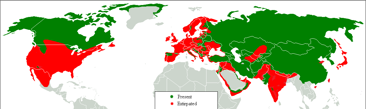
| Beskrywing |
Dansk: Udbredelseskort. Grøn: idag, rød: historisk. English: Range map. Green, present; red, former. Հայերեն: Գայլերի բնակեցման քարտեզ, կանաչ գույնով պատկերված է ներկա արեալը, իսկ կարմիր գույնով՝ պատմական: |
| Datum | |
| Bron | Transferred from en.wikipedia to Commons.;. |
| Outeur | Tommyknocker at Engels Wikipedia |

|
This biogeographical map image could be re-created using vector graphics as an SVG file. This has several advantages; see Commons:Media for cleanup for more information. If an SVG form of this image is available, please upload it and afterwards replace this template with
{{vector version available|new image name}}.
It is recommended to name the SVG file “Gray Wolf Distribution.svg”—then the template Vector version available (or Vva) does not need the new image name parameter. |
Lisensiëring
| This work has been released into the public domain by its author, Tommyknocker at Engels Wikipedia. This applies worldwide. In sommige lande is dit dalk nie wettiglik moontlik nie. Indien so: Tommyknocker grants anyone the right to use this work for any purpose, without any conditions, unless such conditions are required by law. |
Oorspronklike oplaailogboek
Original description page is/was here(All user names refer to en.wikipedia)
- 2007-03-03 12:04 Tommyknocker 1168×347×8 (16467 bytes)
| Annotations | This image is annotated: View the annotations at Commons |
Lêergeskiedenis
Klik op die datum/tyd om te sien hoe die lêer destyds gelyk het.
| Datum/Tyd | Duimnael | Dimensies | Gebruiker | Opmerking | |
|---|---|---|---|---|---|
| huidig | 09:18, 17 Februarie 2018 | 1 168 × 347 (17 KG) | William Harris | Refer discussion page - North America | |
| 09:08, 16 Februarie 2018 | 1 168 × 347 (17 KG) | William Harris | Refer Discussion page - Caucasus, Turkey and Kyrgyzstan | ||
| 06:29, 15 Februarie 2018 | 1 168 × 347 (17 KG) | William Harris | Refer Discussion page - Iran, Pakistan and India | ||
| 05:58, 14 Februarie 2018 | 1 168 × 347 (16 KG) | William Harris | Refer Discussion page - India, Nepal, Bhutan, China | ||
| 11:41, 13 Februarie 2018 | 1 168 × 347 (16 KG) | William Harris | Amended for both Koreas and all but southern China based on IUNC Red List: http://www.iucnredlist.org/details/3746/0 | ||
| 11:36, 12 Februarie 2018 | 1 168 × 347 (16 KG) | William Harris | British Columbia distribution included based on: * https://www.researchgate.net/figure/Map-of-British-Columbia-showing-the-elevation-and-distribution-of-wolf-sampling_fig5_260037025 * http://www.env.gov.bc.ca/fw/wildlife/management-issues/docs/grey_wol... | ||
| 23:55, 9 Februarie 2018 | 1 168 × 347 (16 KG) | Maphobbyist | Complete | ||
| 22:54, 9 Februarie 2018 | 1 168 × 347 (16 KG) | Maphobbyist | Final chck | ||
| 22:38, 9 Februarie 2018 | 1 168 × 347 (16 KG) | Maphobbyist | Again check | ||
| 20:55, 9 Februarie 2018 | 1 168 × 347 (16 KG) | Maphobbyist | Check |
Lêergebruik
Die volgende 2 bladsye gebruik dié lêer:
Globale lêergebruik
Die volgende ander wiki's gebruik hierdie lêer:
- Gebruik in am.wikipedia.org
- Gebruik in azb.wikipedia.org
- Gebruik in bn.wikipedia.org
- Gebruik in bs.wikipedia.org
- Gebruik in cy.wikipedia.org
- Gebruik in de.wikipedia.org
- Gebruik in diq.wikipedia.org
- Gebruik in en.wikipedia.org
- Gebruik in fa.wikipedia.org
- Gebruik in ga.wikipedia.org
- Gebruik in gl.wikipedia.org
- Gebruik in gu.wikipedia.org
- Gebruik in he.wikipedia.org
- Gebruik in hy.wikipedia.org
- Gebruik in hy.wikiquote.org
- Gebruik in ia.wikipedia.org
- Gebruik in ja.wikipedia.org
- Gebruik in kbd.wikipedia.org
- Gebruik in ko.wikipedia.org
- Gebruik in ku.wikipedia.org
- Gebruik in lb.wikipedia.org
- Gebruik in mk.wikipedia.org
- Gebruik in mn.wikipedia.org
- Gebruik in ms.wikipedia.org
- Gebruik in myv.wikipedia.org
- Gebruik in ne.wikipedia.org
- Gebruik in oc.wikipedia.org
- Gebruik in pa.wikipedia.org
- Gebruik in ro.wikipedia.org
- Gebruik in ru.wikipedia.org
- Gebruik in so.wikipedia.org
- Gebruik in stq.wikipedia.org
- Gebruik in sv.wikipedia.org
- Gebruik in ta.wikipedia.org
- Gebruik in tl.wikipedia.org
- Gebruik in zh-min-nan.wikipedia.org
- Gebruik in zh-yue.wikipedia.org