Lêer:Irrigation along the Shebelle River.JPG

Grootte van hierdie voorskou: 800 × 532 piksels. Ander resolusies: 320 × 213 piksels | 640 × 425 piksels | 1 024 × 681 piksels | 1 280 × 851 piksels | 2 560 × 1 701 piksels | 4 288 × 2 850 piksels.
Oorspronklike lêer (4 288 × 2 850 piksels, lêergrootte: 2,57 MG, MIME-tipe: image/jpeg)
Opsomming
| Beskrywing |
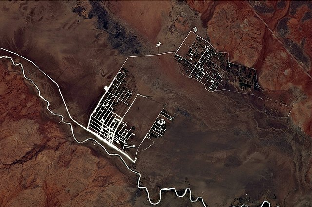
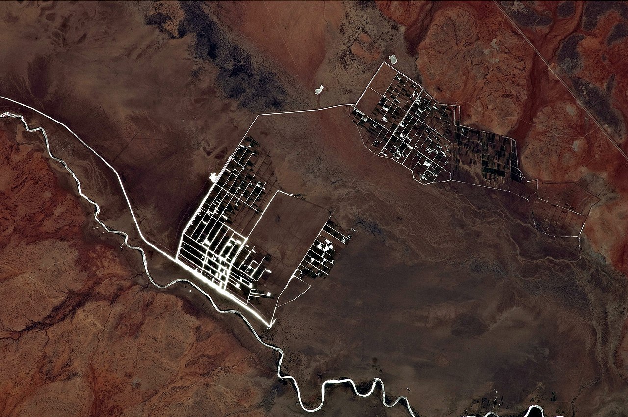
English: This astronaut photograph illustrates a network of irrigation canals and fields located approximately 42 kilometers to the west-northwest of the city of Gode. Floodplain sediments and soils are dark brown to gray (image center), and contrast with the reddish rocks and soils on the adjacent plateau. Vegetation in the flood plain (image top center) and agricultural fields is dark green.
Water in the Shebelle River and the irrigation canals has a bright, mirror-like appearance due to sun-glint, or light reflecting off the water surface back toward the International Space Station. |
| Datum | |
| Bron | NASA Earth Observatory |
| Outeur | ISS Expedition 27 crew |
| Kameraligging | | Hierdie en ander beelde in: OpenStreetMap |
|---|
This image or video was catalogued by Johnson Space Center of the United States National Aeronautics and Space Administration (NASA) under Photo ID: ISS027-E-9564. This tag does not indicate the copyright status of the attached work. A normal copyright tag is still required. See Commons:Licensing. Other languages:
|
Image acquired with a Nikon D2Xs digital camera using a 400 mm lens, and is provided by the ISS Crew Earth Observations experiment and Image Science & Analysis Laboratory, Johnson Space Center.
Lisensiëring
| This file is in the public domain in the United States because it was solely created by NASA. NASA copyright policy states that "NASA material is not protected by copyright unless noted". (See Template:PD-USGov, NASA copyright policy page or JPL Image Use Policy.) | ||
 |
Warnings:
|
Lêergeskiedenis
Klik op die datum/tyd om te sien hoe die lêer destyds gelyk het.
| Datum/Tyd | Duimnael | Dimensies | Gebruiker | Opmerking | |
|---|---|---|---|---|---|
| huidig | 17:09, 11 April 2011 | | 4 288 × 2 850 (2,57 MG) | Originalwana | {{Information |Description ={{en|1=This astronaut photograph illustrates a network of irrigation canals and fields located approximately 42 kilometers to the west-northwest of the city of Gode. Floodplain sediments and soil |
Lêergebruik
Die volgende bladsy gebruik dié lêer:
Globale lêergebruik
Die volgende ander wiki's gebruik hierdie lêer:
- Gebruik in en.wikipedia.org
- Gebruik in fr.wikipedia.org