Lêer:Maldives.visibleearth.nasa.jpg

Grootte van hierdie voorskou: 466 × 599 piksels. Ander resolusies: 187 × 240 piksels | 373 × 480 piksels | 597 × 768 piksels | 796 × 1 024 piksels | 1 400 × 1 800 piksels.
Oorspronklike lêer (1 400 × 1 800 piksels, lêergrootte: 530 KG, MIME-tipe: image/jpeg)

|
This map has been uploaded by Electionworld from en.wikipedia.org to enable the |
Opsomming
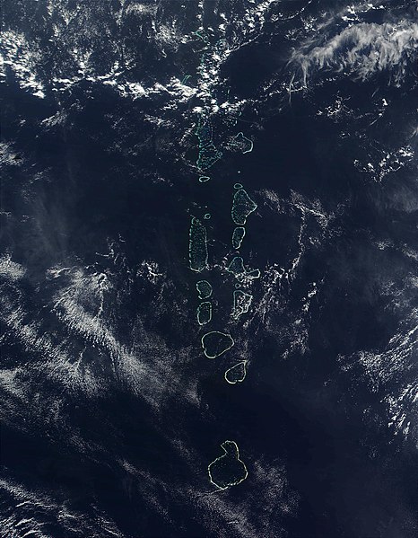
Source: http://visibleearth.nasa.gov
It should be noted that the southern most Atoll of the Maldives, Addu Atoll, is not visible on this image.
Lisensiëring
| This file is in the public domain in the United States because it was solely created by NASA. NASA copyright policy states that "NASA material is not protected by copyright unless noted". (See Template:PD-USGov, NASA copyright policy page or JPL Image Use Policy.) | ||
 |
Warnings:
|
Lêergeskiedenis
Klik op die datum/tyd om te sien hoe die lêer destyds gelyk het.
| Datum/Tyd | Duimnael | Dimensies | Gebruiker | Opmerking | |
|---|---|---|---|---|---|
| huidig | 22:52, 27 November 2006 | | 1 400 × 1 800 (530 KG) | Electionworld | {{ew|en|Oblivious}} == Summary == '''Source:''' [http://veimages.gsfc.nasa.gov/2686/Maldives.A2002090.0525.500m.jpg http://visibleearth.nasa.gov] It should be noted that the southern most Atoll of the Maldives, Addu Atoll, is not visible on this ima |
Lêergebruik
Die volgende bladsy gebruik dié lêer:
Globale lêergebruik
Die volgende ander wiki's gebruik hierdie lêer:
- Gebruik in ar.wikipedia.org
- Gebruik in en.wikipedia.org
- Gebruik in gl.wikipedia.org
- Gebruik in hi.wikipedia.org
- Gebruik in it.wikipedia.org
- Gebruik in kn.wikipedia.org
- Gebruik in lt.wikipedia.org
- Gebruik in mk.wikipedia.org
- Gebruik in ml.wikipedia.org
- Gebruik in my.wikipedia.org
- Gebruik in pl.wikipedia.org
- Gebruik in sd.wikipedia.org
- Gebruik in sr.wikipedia.org
- Gebruik in ta.wikipedia.org
- Gebruik in th.wikipedia.org
- Gebruik in trv.wikipedia.org
- Gebruik in tr.wikipedia.org
- Gebruik in uk.wikipedia.org
- Gebruik in vi.wikipedia.org
- Gebruik in zh.wikipedia.org