Lêer:Manhattan Project US Canada Map 2.svg

Size of this PNG preview of this SVG file: 800 × 508 piksels. Ander resolusies: 320 × 203 piksels | 640 × 407 piksels | 1 024 × 651 piksels | 1 280 × 813 piksels | 2 560 × 1 626 piksels | 1 212 × 770 piksels.
Oorspronklike lêer (SVG-lêer, normaalweg 1 212 × 770 piksels, lêergrootte: 305 KG)
Opsomming
| Beskrywing |
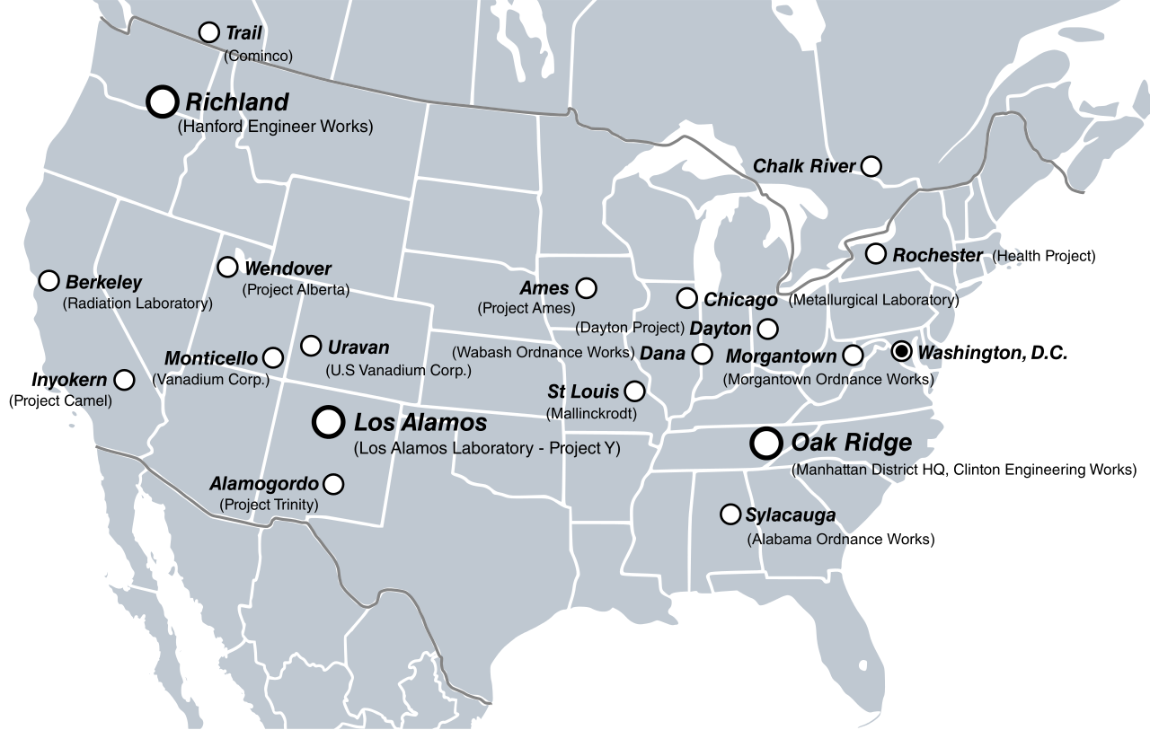
English: Major sites in the U.S. and Canada involved in the Manhattan Project. |
| Datum | |
| Bron |
Eie werk
|
| Outeur | Fallschirmjäger |
| Ander weergawes | File:Manhattan Project US Map.png |

|
The file size of this SVG image may be abnormally large because most or all of its text has been converted to paths rather than using the more conventional
<text> element. Unless rendering the text of the SVG file produces an image with text that is incurably unreadable due to technical limitations, it is highly recommended to change the paths back to text. Doing so will ease the process of localizing this image to other languages and is likely to reduce the file size in a significant scale. Other SVGs containing path-based text can be found at Category:Path text SVG. For more information, see SVG: Fonts and Preparing images for upload: Text.
|

|
Lisensiëring
Ek, die outeursreghouer van hierdie werk, publiseer dit onder die volgende lisensie:
Hierdie lêer is gelisensieer onder die Creative Commons Erkenning-Insgelyks Deel 3.0 Onoorgedraagde lisensie.
- U is vry:
- om te deel – die werk kopieer, versprei en deurgee
- om te hermeng – om die werk aan te pas
- Onder die volgende voorwaardes:
- naamsvermelding – U moet die nodige krediet gee, 'n skakel na die lisensie verskaf en aandui of daar veranderinge aangebring is. U mag dit op enige redelike manier doen, maar nie op enige manier wat daarop dui dat die lisensiegewer u of u gebruik onderskryf nie.
- insgelyks – As u die materiaal hermix, transformeer of voortbou, moet u u bydraes versprei onder die dieselfde of versoenbare lisensie as die oorspronklike.
Lêergeskiedenis
Klik op die datum/tyd om te sien hoe die lêer destyds gelyk het.
| Datum/Tyd | Duimnael | Dimensies | Gebruiker | Opmerking | |
|---|---|---|---|---|---|
| huidig | 12:52, 20 Julie 2011 | | 1 212 × 770 (305 KG) | Liandrei | Added more sites & Mexico |
| 12:56, 1 Julie 2011 |  | 1 212 × 770 (199 KG) | Liandrei | {{Information |Description={{en|Major sites in the U.S. and Canada involved in the Manhattan Project.}} |Source={{own}} *Base map from: File:BlankMap-USA-states-Canada-provinces, HI closer.svg |Date=2011-06-30 |Author= [[Use |
Lêergebruik
Die volgende bladsy gebruik dié lêer:
Globale lêergebruik
Die volgende ander wiki's gebruik hierdie lêer:
- Gebruik in ast.wikipedia.org
- Gebruik in ca.wikipedia.org
- Gebruik in cs.wikipedia.org
- Gebruik in da.wikipedia.org
- Gebruik in en.wikipedia.org
- Manhattan Project
- Talk:List of National Natural Landmarks in Michigan
- User:Pahazzard/sandbox
- Wikipedia:Graphics Lab/Illustration workshop/Archive/Jul 2011
- Wikipedia:Featured picture candidates/July-2011
- Wikipedia:Featured picture candidates/Manhattan Project clickable site map
- User:Arlene.crabtree/sandbox
- Gebruik in fr.wikipedia.org
- Gebruik in ga.wikipedia.org
- Gebruik in he.wikipedia.org
- Gebruik in hi.wikipedia.org
- Gebruik in hu.wikipedia.org
- Gebruik in ja.wikipedia.org
- Gebruik in no.wikipedia.org
- Gebruik in pt.wikipedia.org
- Gebruik in ro.wikipedia.org
- Gebruik in ru.wikipedia.org
- Gebruik in tt.wikipedia.org
- Gebruik in vi.wikipedia.org
- Gebruik in www.wikidata.org