Lêer:Map-of-southeast-asia 900 CE.svg

Size of this PNG preview of this SVG file: 426 × 600 piksels. Ander resolusies: 170 × 240 piksels | 341 × 480 piksels | 545 × 768 piksels | 727 × 1 024 piksels | 1 454 × 2 048 piksels | 791 × 1 114 piksels.
Oorspronklike lêer (SVG-lêer, normaalweg 791 × 1 114 piksels, lêergrootte: 124 KG)
Opsomming
| Beskrywing |
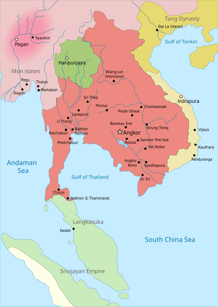
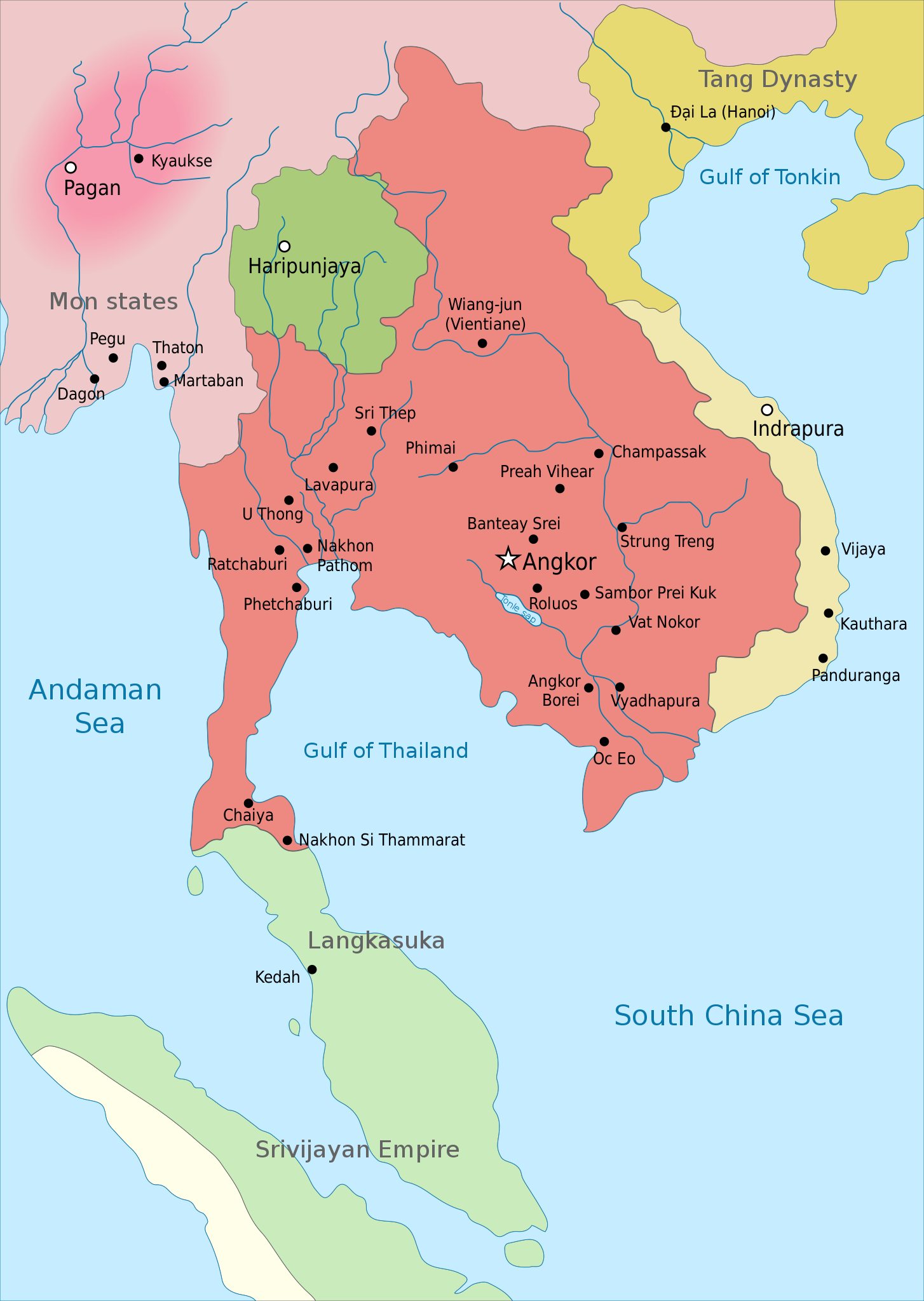
English: Map of Southeast Asia circa 900 CE, showing the Khmer Empire in red, Champa in yellow and Haripunjaya in light Green plus additional surrounding states. |
| Datum | |
| Bron | Own work based on: Map-of-southeast-asia 900 CE.png |
| Outeur | Jembezmamy |
| Ander weergawes |
|
| SVG genesis | This map was created with Adobe Illustrator. |


Lisensiëring
Ek, die outeursreghouer van hierdie werk, publiseer dit onder die volgende lisensie:
| This file is made available under the Creative Commons CC0 1.0 Universal Public Domain Dedication. | |
| The person who associated a work with this deed has dedicated the work to the public domain by waiving all of their rights to the work worldwide under copyright law, including all related and neighboring rights, to the extent allowed by law. You can copy, modify, distribute and perform the work, even for commercial purposes, all without asking permission.
|
Lêergeskiedenis
Klik op die datum/tyd om te sien hoe die lêer destyds gelyk het.
| Datum/Tyd | Duimnael | Dimensies | Gebruiker | Opmerking | |
|---|---|---|---|---|---|
| huidig | 21:13, 31 Maart 2016 | | 791 × 1 114 (124 KG) | Jembezmamy | New colors |
| 20:17, 31 Maart 2016 |  | 791 × 1 114 (124 KG) | Jembezmamy | User created page with UploadWizard |
Lêergebruik
Die volgende bladsy gebruik dié lêer:
Globale lêergebruik
Die volgende ander wiki's gebruik hierdie lêer:
- Gebruik in ar.wikipedia.org
- Gebruik in ast.wikipedia.org
- Gebruik in bn.wikipedia.org
- Gebruik in ca.wikipedia.org
- Gebruik in da.wikipedia.org
- Gebruik in de.wikipedia.org
- Gebruik in en.wikipedia.org
- Gebruik in fr.wikipedia.org
- Gebruik in hu.wikipedia.org
- Gebruik in ko.wikipedia.org
- Gebruik in lo.wikipedia.org
- Gebruik in lt.wikipedia.org
- Gebruik in lv.wikipedia.org
- Gebruik in pl.wikipedia.org
- Gebruik in pt.wikipedia.org
- Gebruik in ru.wikipedia.org
- Gebruik in shi.wikipedia.org
- Gebruik in sh.wikipedia.org
- Gebruik in sl.wikipedia.org
- Gebruik in sr.wikipedia.org
- Gebruik in th.wikipedia.org
- Gebruik in tl.wikipedia.org
- Gebruik in uz.wikipedia.org
- Gebruik in vi.wikipedia.org
- Gebruik in www.wikidata.org
- Gebruik in zh-yue.wikipedia.org