Lêer:NASA Manhattan.jpg

Grootte van hierdie voorskou: 253 × 599 piksels. Ander resolusies: 101 × 240 piksels | 604 × 1 431 piksels.
Oorspronklike lêer (604 × 1 431 piksels, lêergrootte: 599 KG, MIME-tipe: image/jpeg)
Opsomming
| Beskrywing |
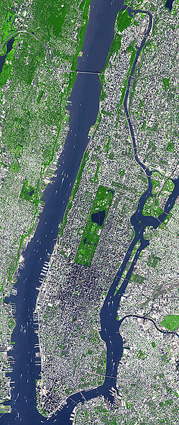
English: This false-color satellite image shows Manhattan, with Queens and Brookyn to the south east and New Jersey to the west. Central Park is visible in the center. This false-color image was acquired on Sept. 8, 2002, by the Advanced Spaceborne Thermal Emission and Reflection Radiometer (ASTER) aboard NASA's Terra satellite. Vegetated land surface is green, paved urban areas are a whitish blue, and water is dark blue. Image cropped by the uploader on 5 August 2006. |
| Datum | |
| Bron | http://earthobservatory.nasa.gov/Newsroom/NewImages/images.php3?img_id=15368 |
| Outeur | Image courtesy NASA/GSFC/MITI/ERSDAC/JAROS, and U.S./Japan ASTER Science Team |
| Ander weergawes | Derivative works of this file: Manhattanhenge map.svg |
Lisensiëring
| This file is in the public domain in the United States because it was solely created by NASA. NASA copyright policy states that "NASA material is not protected by copyright unless noted". (See Template:PD-USGov, NASA copyright policy page or JPL Image Use Policy.) | ||
 |
Warnings:
|
Oorspronklike oplaailogboek
The original description page was here. All following user names refer to en.wikipedia.
- 2006-08-05 18:48 Wv235 604×1431×8 (613881 bytes) This false-color satellite image shows Manhattan, with Queens and Brookyn to the south east and New Jersey to the west. Central Park is visible in the center. This false-color image was acquired on Sept. 8, 2002, by the Advanced Spaceborne Thermal Emissi
Lêergeskiedenis
Klik op die datum/tyd om te sien hoe die lêer destyds gelyk het.
| Datum/Tyd | Duimnael | Dimensies | Gebruiker | Opmerking | |
|---|---|---|---|---|---|
| huidig | 13:49, 24 Junie 2007 | | 604 × 1 431 (599 KG) | Ulfer | {{Information |Description=This false-color satellite image shows Manhattan, with Queens and Brookyn to the south east and New Jersey to the west. Central Park is visible in the center. This false-color image was acquired on Sept. 8, 2002, by the Advance |
Lêergebruik
Die volgende bladsy gebruik dié lêer:
Globale lêergebruik
Die volgende ander wiki's gebruik hierdie lêer:
- Gebruik in cs.wikipedia.org
- Gebruik in cy.wikipedia.org
- Gebruik in de.wikipedia.org
- Gebruik in en.wikipedia.org
- Gebruik in en.wiktionary.org
- Gebruik in et.wikipedia.org
- Gebruik in fa.wikipedia.org
- Gebruik in fo.wikipedia.org
- Gebruik in fr.wikipedia.org
- Gebruik in gu.wikipedia.org
- Gebruik in he.wikipedia.org
- Gebruik in hi.wikipedia.org
- Gebruik in it.wikipedia.org
- Gebruik in kn.wikipedia.org
- Gebruik in ko.wikipedia.org
- Gebruik in mai.wikipedia.org
- Gebruik in ml.wikipedia.org
- Gebruik in no.wikipedia.org
- Gebruik in pt.wikipedia.org
- Gebruik in ru.wikipedia.org
- Gebruik in scn.wikipedia.org
- Gebruik in simple.wikipedia.org
- Gebruik in ta.wikipedia.org
- Gebruik in uk.wikipedia.org
- Gebruik in yi.wikipedia.org
- Gebruik in zh.wikipedia.org