Lêer:Newyork heat island.jpg

Grootte van hierdie voorskou: 298 × 598 piksels. Ander resolusies: 119 × 240 piksels | 540 × 1 084 piksels.
Oorspronklike lêer (540 × 1 084 piksels, lêergrootte: 149 KG, MIME-tipe: image/jpeg)
Opsomming
| Beskrywing |
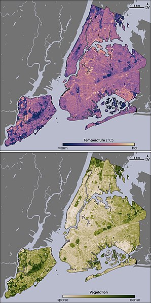
English: Thermal infrared satellite data measured by NASAâs Landsat Enhanced Thematic Mapper Plus on August 14, 2002 one of the hottest days in New York City's summer. Landsat also collected vegetation data. Image from NASA EArth Observatory web page <http://earthobservatory.nasa.gov/Newsroom/NewImages/images.php3?img_id=17354> --Ryanjo 23:43, 1 August 2006 (UTC) |
| Bron | NASA |
| Outeur | |
| Ander weergawes |
 |
Lisensiëring
| This file is in the public domain in the United States because it was solely created by NASA. NASA copyright policy states that "NASA material is not protected by copyright unless noted". (See Template:PD-USGov, NASA copyright policy page or JPL Image Use Policy.) | ||
 |
Warnings:
|
Oorspronklike oplaailogboek
The original description page was here. All following user names refer to en.wikipedia.
- 2006-08-01 23:43 Ryanjo 540×1084× (152802 bytes) Thermal infrared satellite data measured by NASAâs Landsat Enhanced Thematic Mapper Plus on August 14, 2002 one of the hottest days in New York City's summer. Landsat also collected vegetation data. Image from NASA EArth Observatory web page <http://ear
Lêergeskiedenis
Klik op die datum/tyd om te sien hoe die lêer destyds gelyk het.
| Datum/Tyd | Duimnael | Dimensies | Gebruiker | Opmerking | |
|---|---|---|---|---|---|
| huidig | 14:49, 23 Februarie 2009 | | 540 × 1 084 (149 KG) | File Upload Bot (Magnus Manske) | {{BotMoveToCommons|en.wikipedia|year={{subst:CURRENTYEAR}}|month={{subst:CURRENTMONTHNAME}}|day={{subst:CURRENTDAY}}}} {{Information |Description={{en|Thermal infrared satellite data measured by NASAâs Landsat Enhanced Thematic Mapper Plus on August |
Lêergebruik
Die volgende bladsy gebruik dié lêer:
Globale lêergebruik
Die volgende ander wiki's gebruik hierdie lêer:
- Gebruik in ca.wikipedia.org
- Gebruik in da.wikipedia.org
- Gebruik in en.wikipedia.org
- Gebruik in eo.wikipedia.org
- Gebruik in et.wikipedia.org
- Gebruik in fa.wikipedia.org
- Gebruik in fr.wikipedia.org
- Gebruik in fr.wikibooks.org
- Gebruik in he.wikipedia.org
- Gebruik in hr.wikipedia.org
- Gebruik in ja.wikipedia.org
- Gebruik in ko.wikipedia.org
- Gebruik in ms.wikipedia.org
- Gebruik in nn.wikipedia.org
- Gebruik in ta.wikipedia.org
- Gebruik in th.wikipedia.org
- Gebruik in zh.wikipedia.org