Lêer:Satellite image of Bangladesh in October 2001.jpg

Grootte van hierdie voorskou: 554 × 599 piksels. Ander resolusies: 222 × 240 piksels | 444 × 480 piksels | 710 × 768 piksels | 947 × 1 024 piksels | 2 214 × 2 394 piksels.
Oorspronklike lêer (2 214 × 2 394 piksels, lêergrootte: 674 KG, MIME-tipe: image/jpeg)
| Beskrywing |
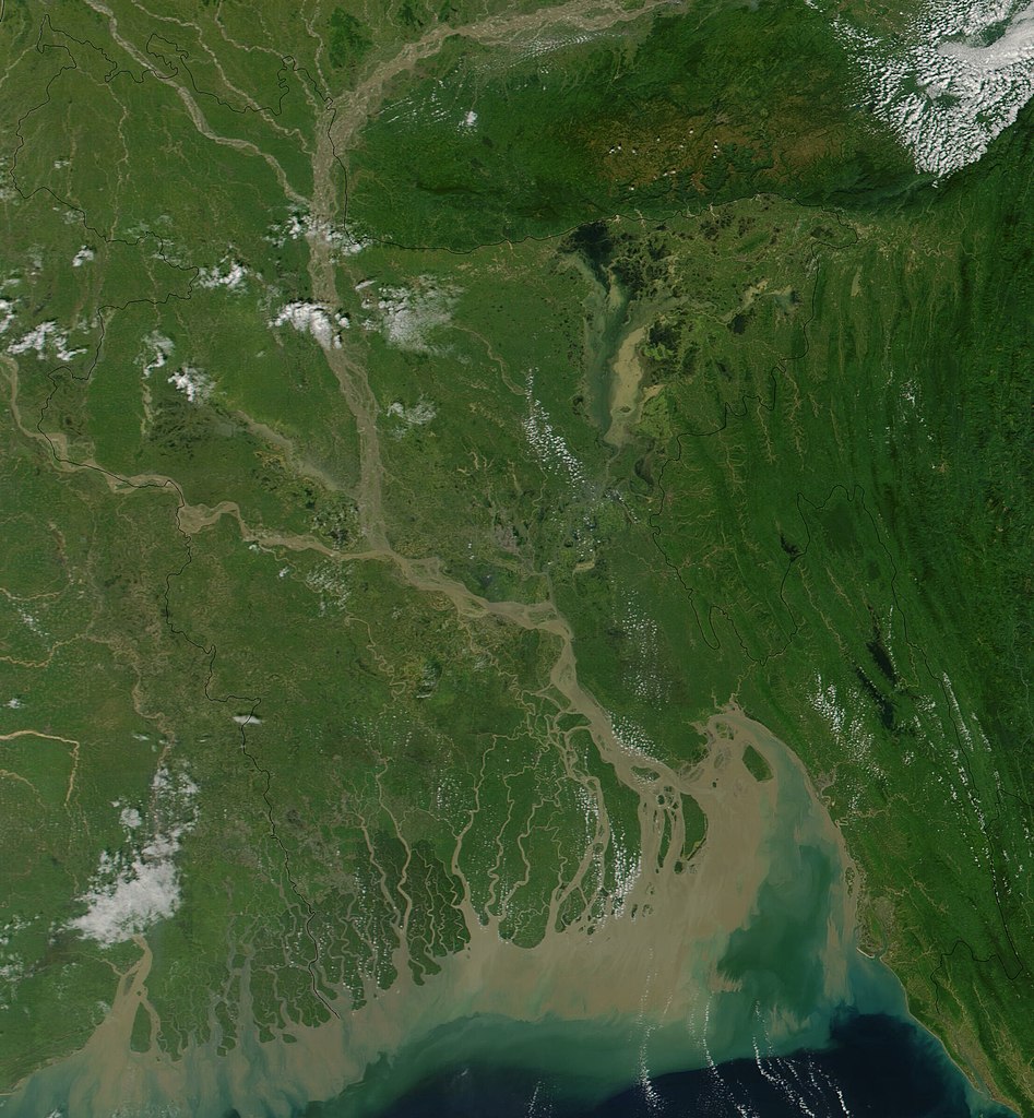
Satellite image of Bangladesh in October 2001 True-color MODIS image from October 23, 2001. Lush with vegetation to the south, numerous rivers, brown with churned up sediment, flow into the valley of the Brahmaputra River in Assam, India. The Brahmaputra turns southward at the border of Bangladesh and is soon joined by the Ganges River, flowing in from image left. The mighty river splits into numerous channels as it runs out toward the Bay of Bengal, giving the region the name "Mouths of the Ganges." Vast amounts of sediment are being emptied into the Bay by the river, and greenish blue swirls could be a mixture of sediment and phytoplankton. |
| Datum | |
| Bron | Cropped from Visible Earth |
| Outeur | Jacques Descloitres, MODIS Land Rapid Response Team, NASA/GSFC |
| This file is in the public domain in the United States because it was solely created by NASA. NASA copyright policy states that "NASA material is not protected by copyright unless noted". (See Template:PD-USGov, NASA copyright policy page or JPL Image Use Policy.) | ||
 |
Warnings:
|
Lêergeskiedenis
Klik op die datum/tyd om te sien hoe die lêer destyds gelyk het.
| Datum/Tyd | Duimnael | Dimensies | Gebruiker | Opmerking | |
|---|---|---|---|---|---|
| huidig | 15:38, 18 Desember 2004 | | 2 214 × 2 394 (674 KG) | Hautala | {{PD-USGov-NASA}} Satellite image of Bangladesh in October 2001. Original image taken from NASA's Visible Earth http://visibleearth.nasa.gov/cgi-bin/viewrecord?10722 |
Lêergebruik
Die volgende bladsy gebruik dié lêer:
Globale lêergebruik
Die volgende ander wiki's gebruik hierdie lêer:
- Gebruik in ar.wikipedia.org
- Gebruik in ast.wikipedia.org
- Gebruik in as.wikipedia.org
- Gebruik in ba.wikipedia.org
- Gebruik in be-tarask.wikipedia.org
- Gebruik in bg.wikipedia.org
- Gebruik in bm.wikipedia.org
- Gebruik in bn.wikipedia.org
- Gebruik in bs.wikipedia.org
- Gebruik in ca.wikipedia.org
- Gebruik in cs.wikipedia.org
- Gebruik in de.wikipedia.org
- Gebruik in en.wikipedia.org
- Gebruik in en.wikiquote.org
- Gebruik in es.wikipedia.org
- Gebruik in fi.wikipedia.org
- Gebruik in frr.wikipedia.org
- Gebruik in id.wikipedia.org
- Gebruik in it.wikipedia.org
- Gebruik in jv.wikipedia.org
- Gebruik in lt.wikipedia.org
- Gebruik in new.wikipedia.org
- Gebruik in nl.wikipedia.org
- Gebruik in no.wikipedia.org
- Gebruik in pl.wikipedia.org
- Gebruik in pt.wikipedia.org
- Gebruik in roa-tara.wikipedia.org
- Gebruik in ru.wikipedia.org
- Gebruik in sh.wikipedia.org
- Gebruik in sr.wikipedia.org
- Gebruik in ta.wikipedia.org
- Gebruik in te.wikipedia.org
- Gebruik in tg.wikipedia.org
- Gebruik in th.wikipedia.org
- Gebruik in uk.wikipedia.org
- Gebruik in vi.wikipedia.org
Wys meer globale gebruik van die lêer.