Lêer:Satellite image of Hokkaido, Japan in May 2001.jpg

Grootte van hierdie voorskou: 450 × 600 piksels. Ander resolusies: 180 × 240 piksels | 360 × 480 piksels | 576 × 768 piksels | 768 × 1 024 piksels | 2 400 × 3 200 piksels.
Oorspronklike lêer (2 400 × 3 200 piksels, lêergrootte: 466 KG, MIME-tipe: image/jpeg)
Opsomming
| Beskrywing |
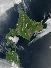
English: Satellite image of Hokkaido, Japan in May 2001. Taken from NASA's Visible Earth http://visibleearth.nasa.gov/view_rec.php?id=2060. This MODIS true-color image shows Hokkaido, Japan, at the top, and the northern tip of the island off Honshu at the bottom. Русский: Спутниковый снимок Хоккайдо (спутник Терра, NASA MODIS; май 2001 года) |
| Datum | |
| Bron | NASA |
| Outeur | NASA |
Lisensiëring
| This file is in the public domain in the United States because it was solely created by NASA. NASA copyright policy states that "NASA material is not protected by copyright unless noted". (See Template:PD-USGov, NASA copyright policy page or JPL Image Use Policy.) | ||
 |
Warnings:
|
derivative works
Derivative works of this file: Akan volcano meakan-dake hokkaido japan space shot.jpg
| Annotations | This image is annotated: View the annotations at Commons |
Lêergeskiedenis
Klik op die datum/tyd om te sien hoe die lêer destyds gelyk het.
| Datum/Tyd | Duimnael | Dimensies | Gebruiker | Opmerking | |
|---|---|---|---|---|---|
| huidig | 21:50, 7 Mei 2006 | | 2 400 × 3 200 (466 KG) | Akanemoto~commonswiki | Satellite image of Hokkaido, Japan in May 2001. Taken from NASA's Visible Earth http://visibleearth.nasa.gov/view_rec.php?id=2060 |
Lêergebruik
Die volgende bladsy gebruik dié lêer:
Globale lêergebruik
Die volgende ander wiki's gebruik hierdie lêer:
- Gebruik in ar.wikipedia.org
- Gebruik in arz.wikipedia.org
- Gebruik in ast.wikipedia.org
- Gebruik in bo.wikipedia.org
- Gebruik in ca.wikipedia.org
- Gebruik in en.wikipedia.org
- Gebruik in en.wiktionary.org
- Gebruik in eu.wikipedia.org
- Gebruik in fr.wikipedia.org
- Gebruik in ga.wikipedia.org
- Gebruik in gl.wikipedia.org
- Gebruik in ha.wikipedia.org
- Gebruik in hy.wikipedia.org
- Gebruik in id.wikipedia.org
- Gebruik in incubator.wikimedia.org
- Gebruik in it.wikipedia.org
- Gebruik in ja.wikipedia.org
- Gebruik in ja.wikibooks.org
- Gebruik in ko.wikipedia.org
- Gebruik in la.wikipedia.org
- Gebruik in ml.wikipedia.org
- Gebruik in nn.wikipedia.org
- Gebruik in oc.wikipedia.org
- Gebruik in pam.wikipedia.org
- Gebruik in pl.wikipedia.org
- Gebruik in pl.wiktionary.org
- Gebruik in pnb.wikipedia.org
- Gebruik in pt.wikipedia.org
- Gebruik in ru.wikipedia.org
- Gebruik in ru.wikinews.org
- Gebruik in sco.wikipedia.org
- Gebruik in simple.wikipedia.org
- Gebruik in sq.wikipedia.org
- Gebruik in sr.wikipedia.org
- Gebruik in sv.wikipedia.org
- Gebruik in szl.wikipedia.org
- Gebruik in ta.wikipedia.org
- Gebruik in tg.wikipedia.org
- Gebruik in uk.wikipedia.org
- Gebruik in ur.wikipedia.org
- Gebruik in vec.wikipedia.org
- Gebruik in vi.wikipedia.org
Wys meer globale gebruik van die lêer.