Lêer:Schina sea 88.png

Grootte van hierdie voorskou: 487 × 600 piksels. Ander resolusies: 195 × 240 piksels | 390 × 480 piksels | 979 × 1 206 piksels.
Oorspronklike lêer (979 × 1 206 piksels, lêergrootte: 1,79 MG, MIME-tipe: image/png)

|
This map image could be re-created using vector graphics as an SVG file. This has several advantages; see Commons:Media for cleanup for more information. If an SVG form of this image is available, please upload it and afterwards replace this template with
{{vector version available|new image name}}.
It is recommended to name the SVG file “Schina sea 88.svg”—then the template Vector version available (or Vva) does not need the new image name parameter. |
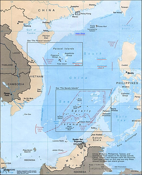
| Beskrywing | Map of the South China Sea | |||
| Datum | ||||
| Bron | Asia Maps — Perry-Castañeda Map Collection: South China Sea (Islands) 1988 | |||
| Outeur | U.S. Central Intelligence Agency | |||
| Toestemming (Hergebruik van die lêer) |
|

Lêergeskiedenis
Klik op die datum/tyd om te sien hoe die lêer destyds gelyk het.
| Datum/Tyd | Duimnael | Dimensies | Gebruiker | Opmerking | |
|---|---|---|---|---|---|
| huidig | 07:13, 9 Mei 2014 | | 979 × 1 206 (1,79 MG) | Philg88 | Removed UK and Portugal tags for Hong Kong and Macau |
| 13:40, 1 April 2009 |  | 979 × 1 206 (1,83 MG) | Jappalang | Removed the borders and surrounding text labels | |
| 08:12, 26 Mei 2007 |  | 996 × 1 256 (3,59 MG) | Ratzer | Source: [http://www.lib.utexas.edu/maps/] from the [http://www.lib.utexas.edu/maps/ Perry-Castañeda Library Map Collection]. {{PD-USGov-CIA}} |
Lêergebruik
Die volgende bladsy gebruik dié lêer:
Globale lêergebruik
Die volgende ander wiki's gebruik hierdie lêer:
- Gebruik in als.wikipedia.org
- Gebruik in ar.wikipedia.org
- Gebruik in bg.wikipedia.org
- Gebruik in ca.wikipedia.org
- Gebruik in da.wikipedia.org
- Gebruik in de.wikipedia.org
- Gebruik in de.wikinews.org
- Gebruik in el.wikipedia.org
- Gebruik in el.wikinews.org
- Gebruik in en.wikipedia.org
- Gebruik in en.wikinews.org
- Gebruik in en.wiktionary.org
- Gebruik in es.wikipedia.org
- Gebruik in fi.wikipedia.org
- Gebruik in fr.wikipedia.org
- Gebruik in he.wikipedia.org
- Gebruik in id.wikipedia.org
- Gebruik in incubator.wikimedia.org
- Wn/vi/Trung Quốc triển khai 5 tàu chiến gần lãnh hải Philippines
- Template:Wn/vi/Biển Đông
- Wn/vi/Vì sao Trung Quốc dùng chiến lược "mơ hồ" ở Biển Đông?
- Wn/vi/Biển Đông: Manila phản đối các hành vi sách nhiễu mới của Bắc Kinh
- Category:Wn/shn/ပၢင်ႇလၢႆႇၸၢၼ်းၶႄႇ
- Wn/shn/ၶႄႇလဵပ်ႈယၢမ်း ၽွင်းၵၢၼ်ႇလႄႈ ဢူၺ်းလီမၼ်း တိုၵ်ႉၽိုၵ်းၵၢၼ်သိုၵ်း တီႈပၢင်ႇလၢႆႇၸၢၼ်းၶႄႇ
- Gebruik in ja.wikipedia.org
- Gebruik in ko.wikipedia.org
- Gebruik in ms.wikipedia.org
- Gebruik in nl.wikipedia.org
- Gebruik in no.wikipedia.org
Wys meer globale gebruik van die lêer.