Lêer:Sedan Plowshare Crater.jpg
Grootte van hierdie voorskou: 755 × 599 piksels. Ander resolusies: 302 × 240 piksels | 605 × 480 piksels | 968 × 768 piksels | 1 280 × 1 016 piksels | 1 426 × 1 132 piksels.
Oorspronklike lêer (1 426 × 1 132 piksels, lêergrootte: 202 KG, MIME-tipe: image/jpeg)
|
This is an image of a place or building that is listed on the National Register of Historic Places in the United States of America. Its reference number is 94000183. |
| Beskrywing |
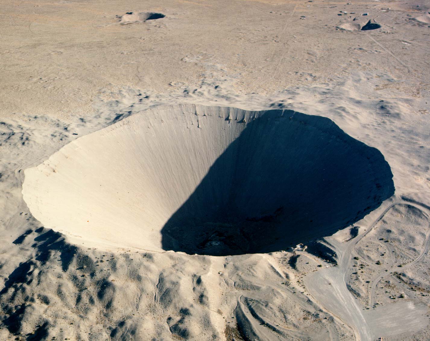
English: Crater from the 1962 "Sedan" nuclear test as part of Operation Plowshare. The 104 kiloton blast displaced 12 million tons of earth and created a crater 320 feet deep and 1,280 feet wide. (Look to the size of the roads in the bottom-right of the picture, and the observation deck at the lower-right edge of the crater, for a sense of scale) العربية: فوهة بركان سيدان هي نتيجة اختبار سيدان النووي ويقع داخل موقع اختبار نيفادا، على بعد 12 ميلاً (19 كم) جنوب غرب بحيرة جرووم |
|
| Bron |
|
|
| Outeur | Federal Government of the United States |
| Kameraligging | | Hierdie en ander beelde in: OpenStreetMap |
|---|
Hierdie beeld is gekies as beeld van die dag op 27 Januarie 2006. Die beeld het die volgende beskrywing: English: Crater from a nuclear test at Nevada Test Site. Ander tale:
Čeština: Kráter po zkušebním jaderném výbuchu v Nevadě. Cymraeg: Crater oddiwrth brawf niwcliar yn y Seit Profi Nevada. Dansk: Krater fra en kernevåben-test i testområdet i Nevada, USA. Deutsch: Krater von einem Nukleartest auf dem Nevadatestgelände English: Crater from a nuclear test at Nevada Test Site. Italiano: Cratere provocato da un test nucleare nel Nevada Test Site. Magyar: Egy nukleáris robbantás krátere. Nevada, USA. Nederlands: Krater als gevolg van een nucleaire test op de testvlakte in Nevada. Polski: Krater w strefie testów nuklearnych w stanie Nevada Slovenščina: Krater jedrskega preizkusa na preizkuševalnem območju Nevada. ગુજરાતી : નેવાડાના ન્યુક્લિયર પરિક્ષણ મથક પર ભૂગર્ભ પરિક્ષણ બાદ રહેલો ખાડો. 한국어: 네바다 핵실험 장소에 있는 폭탄 구멍. العربية : حفرة هائلة جراء انفجار نووي في منطقة الاختبارات النووية بولاية نيفادا الأمريكية |
This work is in the public domain in the United States because it is a work prepared by an officer or employee of the United States Government as part of that person’s official duties under the terms of Title 17, Chapter 1, Section 105 of the US Code.
Note: This only applies to original works of the Federal Government and not to the work of any individual U.S. state, territory, commonwealth, county, municipality, or any other subdivision. This template also does not apply to postage stamp designs published by the United States Postal Service since 1978. (See § 313.6(C)(1) of Compendium of U.S. Copyright Office Practices). It also does not apply to certain US coins; see The US Mint Terms of Use.
|
 | |
| Hierdie lêer is geïdentifiseer as vry van bekende beperkings onder kopiereg, insluitend alle verwante en naburige regte. | ||
Lêergeskiedenis
Klik op die datum/tyd om te sien hoe die lêer destyds gelyk het.
| Datum/Tyd | Duimnael | Dimensies | Gebruiker | Opmerking | |
|---|---|---|---|---|---|
| huidig | 17:49, 11 Desember 2005 | | 1 426 × 1 132 (202 KG) | Fastfission~commonswiki | even higher res |
| 20:30, 22 Mei 2005 |  | 685 × 543 (338 KG) | Xenoforme~commonswiki |
Lêergebruik
Die volgende bladsy gebruik dié lêer:
Globale lêergebruik
Die volgende ander wiki's gebruik hierdie lêer:
- Gebruik in ar.wikipedia.org
- Gebruik in beta.wikiversity.org
- Gebruik in bg.wikipedia.org
- Gebruik in ca.wikipedia.org
- Gebruik in ceb.wikipedia.org
- Gebruik in cs.wikipedia.org
- Gebruik in de.wikipedia.org
- Gebruik in de.wiktionary.org
- Gebruik in en.wikipedia.org
- Nuclear explosive
- Nevada Test Site
- Project Plowshare
- Nuclear weapons testing
- Sedan (nuclear test)
- Wikipedia:Recent additions 26
- Peaceful nuclear explosion
- Underground nuclear weapons testing
- Craterization
- Yucca Flat
- Explosion crater
- Wikipedia:Did you know/Statistics/Monthly DYK pageview leaders/2008
- Wikipedia:Recent additions/2005/March
- User:Binksternet/DYK
- Wikipedia:Recent additions/2008/July
- July 1962
- National Register of Historic Places listings in Nye County, Nevada
- User:Boundarylayer/sandbox
- User:Epicgenius/Userpage/Rest of year
- Crater
- User:Ikluft/essay/Categorization of craters
- History of the Petroleum industry in Alberta
- Gebruik in en.wikibooks.org
Wys meer globale gebruik van die lêer.