Lêer:The maximum extent of the Safavid Empire under Shah Abbas I.png
Geen hoër resolusie is beskikbaar nie.
The_maximum_extent_of_the_Safavid_Empire_under_Shah_Abbas_I.png (620 × 428 piksels, lêergrootte: 20 KG, MIME-tipe: image/png)
Opsomming
| Beskrywing |
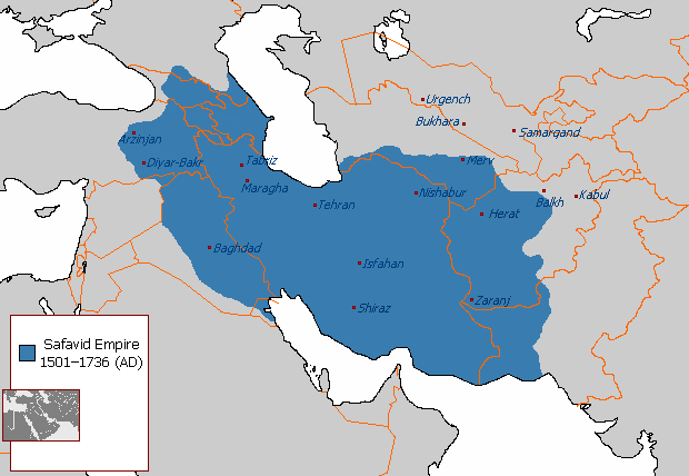
English: The maximum extent of the Safavid Empire under Shah Abbas I. فارسی: حداکثر وسعت امپراتوری صفوی در زمان شاه عباس یکم. |
||
| Bron | File:Safavid_Empire_1501_1722_AD.png | ||
| Outeur | Arab_Hafez, edited by HistoryofIran (me). | ||
| Ander weergawes |
|

Lisensiëring
| This map is ineligible for copyright and therefore in the public domain, because it consists entirely of information that is common property and contains no original authorship. For more information, see Commons:Threshold of originality § Maps.
|
Lêergeskiedenis
Klik op die datum/tyd om te sien hoe die lêer destyds gelyk het.
| Datum/Tyd | Duimnael | Dimensies | Gebruiker | Opmerking | |
|---|---|---|---|---|---|
| huidig | 21:03, 1 Januarie 2018 | | 620 × 428 (20 KG) | HistoryofIran | rv, take your concerns to the talk page |
| 21:54, 30 Desember 2017 |  | 620 × 428 (24 KG) | Qizilbash | Eastern Anatolia has never been under the control of Shah Abbas. After Shah Ismail this region has always been under Ottoman control. | |
| 04:56, 7 Julie 2015 |  | 620 × 428 (20 KG) | HistoryofIran | Removed disprutive edit from banned user. | |
| 02:03, 23 Junie 2015 |  | 620 × 428 (20 KG) | Artin Mehraban | the minor changes are examples of original research which is banned by wikipedia | |
| 04:09, 22 Junie 2015 |  | 620 × 428 (20 KG) | LouisAragon | they didn't rule such area under Abbas sigh. Stop being such a nuisance really. | |
| 23:12, 20 Junie 2015 |  | 620 × 428 (27 KG) | Artin Mehraban | changed the map size | |
| 23:03, 20 Junie 2015 |  | 582 × 401 (25 KG) | Artin Mehraban | It was well known Shah Abbas took daghestan | |
| 20:57, 20 Junie 2015 |  | 582 × 401 (24 KG) | Artin Mehraban | small edits | |
| 19:24, 20 Junie 2015 |  | 582 × 401 (23 KG) | Artin Mehraban | A few minor changes | |
| 04:00, 20 Junie 2015 |  | 585 × 414 (22 KG) | Artin Mehraban | Better text for cities |
Lêergebruik
Die volgende bladsy gebruik dié lêer:
Globale lêergebruik
Die volgende ander wiki's gebruik hierdie lêer:
- Gebruik in azb.wikipedia.org
- Gebruik in az.wikipedia.org
- Gebruik in bn.wikipedia.org
- Gebruik in cs.wikipedia.org
- Gebruik in el.wikipedia.org
- Gebruik in en.wikipedia.org
- Greater Iran
- Abbas II of Persia
- Iranian Armenia (1502–1828)
- Safavid Shirvan
- Safavid Karabakh
- Template:Safavid provinces
- Safavid Georgia
- Safavid Daghestan
- Erivan Province (Safavid Iran)
- User talk:EdJohnston/Archive 44
- User:LouisAragon/sandbox/Dagh
- Safavid Diyarbakr
- User:Falcaorib
- Baghdad Province (Safavid Empire)
- Safavid Talish
- Marie Petit
- Azerbaijan Province (Safavid Iran)
- Safavid Khuzestan
- Safavid Astarabad
- Safavid Lorestan
- Safavid Kandahar
- Safavid Kurdistan
- User:Kailanmapper/sandbox4
- User:Kailanmapper/sandbox5
- Gebruik in en.wikibooks.org
- Gebruik in et.wikipedia.org
- Gebruik in eu.wikipedia.org
- Gebruik in fa.wikipedia.org
Wys meer globale gebruik van die lêer.