Lêer:Trnc-map.gif
Geen hoër resolusie is beskikbaar nie.
Trnc-map.gif (508 × 300 piksels, lêergrootte: 10 KG, MIME-tipe: image/gif)

|
This map has been uploaded by Electionworld from en.wikipedia.org to enable the |

|
The copyright holder of this work allows anyone to use it for any purpose including unrestricted redistribution, commercial use, and modification.
Usage notes:
|
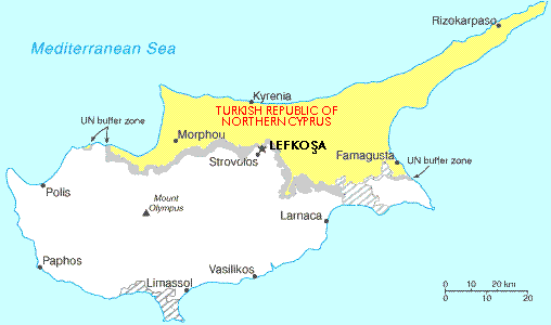
Map showing the Turkish Republic of Northern Cyprus (in yellow). The tiny exclave is called Erenköy.
Lêergeskiedenis
Klik op die datum/tyd om te sien hoe die lêer destyds gelyk het.
| Datum/Tyd | Duimnael | Dimensies | Gebruiker | Opmerking | |
|---|---|---|---|---|---|
| huidig | 22:56, 28 November 2006 | | 508 × 300 (10 KG) | Electionworld | {{ew|en|Expatkiwi}} {{CopyrightedFreeUse}} Map showing the Turkish Republic of Northern Cyprus (in yellow). The tiny exclave is called Erenköy. Category:Maps of Northern Cyprus |
Lêergebruik
Die volgende bladsy gebruik dié lêer:
Globale lêergebruik
Die volgende ander wiki's gebruik hierdie lêer:
- Gebruik in de.wikinews.org
- Gebruik in en.wikipedia.org
- Gebruik in ga.wikipedia.org
- Gebruik in hr.wikipedia.org
- Gebruik in hu.wikipedia.org
- Gebruik in it.wikipedia.org
- Gebruik in nl.wikipedia.org
- Gebruik in ru.wikipedia.org
- Gebruik in su.wikipedia.org
- Gebruik in tr.wikipedia.org
- Gebruik in uz.wikipedia.org