Lêer:TurksandCaicosOMC.png

Grootte van hierdie voorskou: 800 × 554 piksels. Ander resolusies: 320 × 222 piksels | 640 × 443 piksels | 969 × 671 piksels.
Oorspronklike lêer (969 × 671 piksels, lêergrootte: 32 KG, MIME-tipe: image/png)
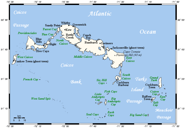
| Beskrywing | A map showing the Turks and Caicos Islands' main towns and islands. This map's source is here, with the uploader's modifications, and the GMT homepage says that the tools are released under the GNU General Public License. | ||||||||
| Datum | |||||||||
| Bron | Originally uploaded by Kelisi to en:Wikipedia (log). | ||||||||
| Outeur | Kelisi (talk) | ||||||||
| Toestemming (Hergebruik van die lêer) |
Kelisi at the English language Wikipedia, die outeursreghouer van hierdie werk, publiseer dit onder die volgende lisensie:
|

Lêergeskiedenis
Klik op die datum/tyd om te sien hoe die lêer destyds gelyk het.
| Datum/Tyd | Duimnael | Dimensies | Gebruiker | Opmerking | |
|---|---|---|---|---|---|
| huidig | 21:46, 4 April 2021 | | 969 × 671 (32 KG) | Kelisi | Newly discovered fact |
| 10:27, 21 Desember 2009 |  | 969 × 671 (25 KG) | Xfigpower | {{Information |Description=A map showing the Turks and Caicos Islands' main towns and islands. This map's source is [http://www.aquarius.ifm-geomar.de/ here], with the uploader's modifications, and the [http://gmt.soest.hawaii.edu/ GMT homepage] says that |
Lêergebruik
Die volgende bladsy gebruik dié lêer:
Globale lêergebruik
Die volgende ander wiki's gebruik hierdie lêer:
- Gebruik in als.wikipedia.org
- Gebruik in ar.wikipedia.org
- Gebruik in br.wikipedia.org
- Gebruik in bs.wikipedia.org
- Gebruik in en.wikipedia.org
- Gebruik in en.wiktionary.org
- Gebruik in es.wikipedia.org
- Gebruik in fa.wikipedia.org
- Gebruik in hr.wikipedia.org
- Gebruik in id.wikipedia.org
- Gebruik in it.wikipedia.org
- Gebruik in ja.wikipedia.org
- Gebruik in ln.wikipedia.org
- Gebruik in lt.wikipedia.org
- Gebruik in mk.wikipedia.org
- Gebruik in pt.wikipedia.org
- Gebruik in ru.wikipedia.org
- Gebruik in sh.wikipedia.org
- Gebruik in simple.wikipedia.org
- Gebruik in sk.wikipedia.org
- Gebruik in uk.wikipedia.org
- Gebruik in vi.wikipedia.org
- Gebruik in zh.wikipedia.org