Lêer:Map of the Grand Duchy of Lithuania (pink) and the Crown of the Kingdom of Poland (red) and its neighborhood in 1386 – 1434 (English version).png

Grootte van hierdie voorskou: 609 × 599 piksels. Ander resolusies: 244 × 240 piksels | 488 × 480 piksels | 781 × 768 piksels | 1 041 × 1 024 piksels | 2 082 × 2 048 piksels | 2 977 × 2 929 piksels.
Oorspronklike lêer (2 977 × 2 929 piksels, lêergrootte: 2,13 MG, MIME-tipe: image/png)
_and_the_Crown_of_the_Kingdom_of_Poland_(red)_and_its_neighborhood_in_1386_%E2%80%93_1434_(English_version).png)
Opsomming
| Beskrywing |
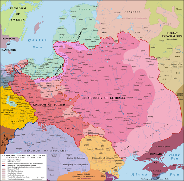
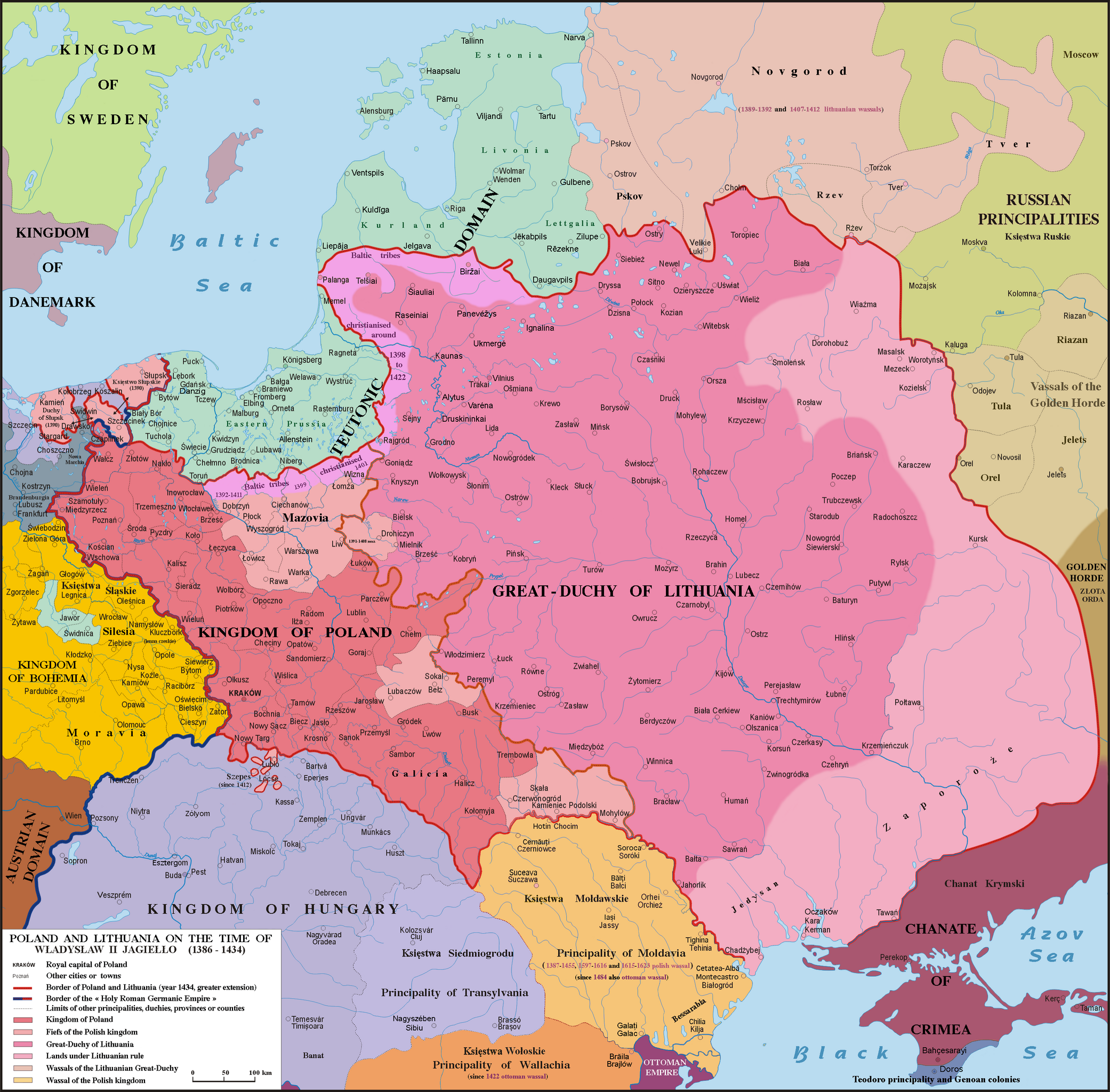
English: Map of Poland, Lithuania & neighbourough 1386-1434. Graphic derivative map since https://fr.wikipedia.org/wiki/Yedisan#/media/File:Polska_1386_-_1434.png but English version and without the 5 mistakes of the original map (impossible to be corrected because the first uploader reverts the new versions) : 1)- Moldavia wasn't a province or a fief (lenno in polish) of the Polish kingdom, but a principality, vassal of Poland from 1387 to 1455, from 1597 to 1616 & from 1615 to 1623 : the Moldavian prince were not a Polish sir appointed by the polish King but a Moldavian boyard elected by the Moldavian Sfat ; 2)- The name Hospodar for the Moldavian princes aren’t in use before the XVIth century ; 3)- In this time Kilja was on the south side of Chilia arm (today Chilia Veche in Romania, not the new Kilija in Ukraine) ; 4)- Danube delta was moldavian till 1484 and the shoreline was different in 1400 ; 5)- Akkerman is not another town but the turkish name (given since 1484) of Bialgorod also named in this time Cetatea-Alba & Montecastro. Sources: Hans-Erich Stier (dir.) "Grosser Atlas zur Weltgeschichte", Ed. Westermann 1985, ISBN 3-14-100919-8, "Történelmi atlasz", Magyar Academy 1991, ISBN 963-351422-3 CM, "Atlas istorico-geografic", Ed. Academica 1994, ISBN 973-27-0500-0, Constantin C. Giurescu & Dinu C. Giurescu :" History of the Romanian lands", Ed. Academica 1985, p.209-210, N. P. Comneanu: "Les principautés roumaines à travers les âges", Ed. Payot, Paris 1919 and Lucian Predescu: "Enciclopedia Cugetarea", p.562-563.
Lietuvių: Lietuvos Didžiosios Kunigaikštystės (rožinė) ir Lenkijos Karalystės Karūnos (raudona) žemėlapis valdant Jogailai 1386 - 1434 m.
Polski: Mapa Polski i Litwy za panowania Władysława II Jagiełły (1386 - 1434). |
| Datum | |
| Bron | File:Polska 1386 - 1434.png |
| Outeur |
Poznaniak (original image) Spiridon Ion Cepleanu (derivative work) |
Lisensiëring
Ek, die outeursreghouer van hierdie werk, publiseer dit onder die volgende lisensie:
This file is licensed under the Creative Commons Attribution-Share Alike 4.0 International license.
- U is vry:
- om te deel – die werk kopieer, versprei en deurgee
- om te hermeng – om die werk aan te pas
- Onder die volgende voorwaardes:
- naamsvermelding – U moet die nodige krediet gee, 'n skakel na die lisensie verskaf en aandui of daar veranderinge aangebring is. U mag dit op enige redelike manier doen, maar nie op enige manier wat daarop dui dat die lisensiegewer u of u gebruik onderskryf nie.
- insgelyks – As u die materiaal hermix, transformeer of voortbou, moet u u bydraes versprei onder die dieselfde of versoenbare lisensie as die oorspronklike.
Lêergeskiedenis
Klik op die datum/tyd om te sien hoe die lêer destyds gelyk het.
| Datum/Tyd | Duimnael | Dimensies | Gebruiker | Opmerking | |
|---|---|---|---|---|---|
| huidig | 17:18, 10 Mei 2016 | | 2 977 × 2 929 (2,13 MG) | Julieta39 | Teodoro principality in Crimea until 1475 |
| 16:11, 6 Desember 2015 |  | 2 977 × 2 929 (2,14 MG) | Spiridon Ion Cepleanu | Correct orthograph of Lithuania in english | |
| 13:56, 6 Desember 2015 |  | 2 977 × 2 929 (2,14 MG) | Spiridon Ion Cepleanu | User created page with UploadWizard |
Lêergebruik
Die volgende bladsy gebruik dié lêer:
Globale lêergebruik
Die volgende ander wiki's gebruik hierdie lêer:
- Gebruik in als.wikipedia.org
- Gebruik in ar.wikipedia.org
- Gebruik in az.wikipedia.org
- Gebruik in be.wikipedia.org
- Gebruik in bg.wikipedia.org
- Gebruik in br.wikipedia.org
- Gebruik in ca.wikipedia.org
- Gebruik in cs.wikipedia.org
- Gebruik in da.wikipedia.org
- Gebruik in de.wikipedia.org
- Gebruik in de.wikibooks.org
- Gebruik in de.wikiversity.org
- Gebruik in el.wikipedia.org
- Gebruik in en.wikipedia.org
- Gebruik in et.wikipedia.org
- Gebruik in fa.wikipedia.org
- Gebruik in fi.wikipedia.org
- Gebruik in fr.wikipedia.org
- Gebruik in gd.wikipedia.org
- Gebruik in hu.wikipedia.org
- Gebruik in it.wikipedia.org
- Gebruik in ja.wikipedia.org
- Gebruik in lt.wikipedia.org
- Gebruik in lt.wikibooks.org
- Gebruik in lv.wikipedia.org
- Gebruik in sl.wikipedia.org
_and_the_Crown_of_the_Kingdom_of_Poland_(red)_and_its_neighborhood_in_1386_–_1434_(English_version).png)