Lêer:ZIP Code zones.svg

Size of this PNG preview of this SVG file: 800 × 548 piksels. Ander resolusies: 320 × 219 piksels | 640 × 438 piksels | 1 024 × 701 piksels | 1 280 × 876 piksels | 2 560 × 1 753 piksels.
Oorspronklike lêer (SVG-lêer, normaalweg 1 024 × 701 piksels, lêergrootte: 836 KG)
| Beskrywing |
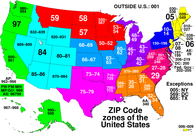
This map of the United States divides the country into ZIP code zones. All states with a common colour use ZIP codes starting with the same digit. Each string of digits, whether two or three digits in length, refers to an allocation which reflects all existing ZIP codes starting with those two or three digits. Nederlands: ZIP code gebieden in de Verenigde Staten |
||
| Datum | |||
| Bron | Own work, based on Image:ZIP_code_zones.png | ||
| Outeur | Denelson83 | ||
| Toestemming (Hergebruik van die lêer) |
|
||
| Ander weergawes | Image:ZIP_code_zones.png |
Lêergeskiedenis
Klik op die datum/tyd om te sien hoe die lêer destyds gelyk het.
| Datum/Tyd | Duimnael | Dimensies | Gebruiker | Opmerking | |
|---|---|---|---|---|---|
| huidig | 19:19, 27 Junie 2007 | | 1 024 × 701 (836 KG) | Denelson83 | Ugh... The PW/MP/MH/GU text was a bit squished |
| 19:14, 27 Junie 2007 |  | 1 024 × 701 (837 KG) | Denelson83 | Adding more detail to the map, and adding an actual map of PR/VI - PD-self | |
| 04:49, 26 Junie 2007 |  | 1 251 × 878 (319 KG) | Denelson83 | Allocations that don't fit the one-digit ZIP Code zone pattern go in the "exceptions" part | |
| 04:47, 26 Junie 2007 |  | 1 251 × 878 (319 KG) | Denelson83 | Allocations that don't fit the one-digit ZIP Code zone pattern go in the "exceptions" part | |
| 04:39, 26 Junie 2007 |  | 1 251 × 878 (319 KG) | Denelson83 | 34 not really visible; using no-break spaces | |
| 04:35, 26 Junie 2007 |  | 1 251 × 878 (319 KG) | Denelson83 | Wrong font; wanted Helvetica, not Verdana | |
| 04:33, 26 Junie 2007 |  | 1 251 × 878 (319 KG) | Denelson83 | {{Information |Description=This map of the United States divides the country into ZIP code zones. All states with a common colour use ZIP codes starting with the same digit. Where only two digits are used, the allocation reflects ''all exis |
Lêergebruik
Die volgende bladsy gebruik dié lêer:
Globale lêergebruik
Die volgende ander wiki's gebruik hierdie lêer:
- Gebruik in av.wikipedia.org
- Gebruik in chr.wikipedia.org
- Gebruik in cs.wikipedia.org
- Gebruik in de.wikipedia.org
- Gebruik in de.wiktionary.org
- Gebruik in en.wikipedia.org
- Gebruik in fa.wikipedia.org
- Gebruik in gu.wikipedia.org
- Gebruik in hi.wikipedia.org
- Gebruik in hu.wikipedia.org
- Gebruik in it.wikipedia.org
- Gebruik in ja.wikipedia.org
- Gebruik in kn.wikipedia.org
- Gebruik in ms.wikipedia.org
- Gebruik in ro.wikipedia.org
- Gebruik in ru.wikipedia.org
- Gebruik in sh.wikipedia.org
- Gebruik in simple.wikipedia.org
- Gebruik in sv.wikipedia.org
- Gebruik in ta.wikipedia.org
- Gebruik in tt.wikipedia.org
- Gebruik in uk.wikipedia.org
- Gebruik in zh.wikipedia.org