Lêer:Snow-cholera-map-1.jpg

Oorspronklike lêer (20 124 × 18 877 piksels, lêergrootte: 18,38 MG, MIME-tipe: image/jpeg)
Opsomming
| Warning | The original file is very high-resolution. It might not load properly or could cause your browser to freeze when opened at full size. |
|---|
| Beskrywing |
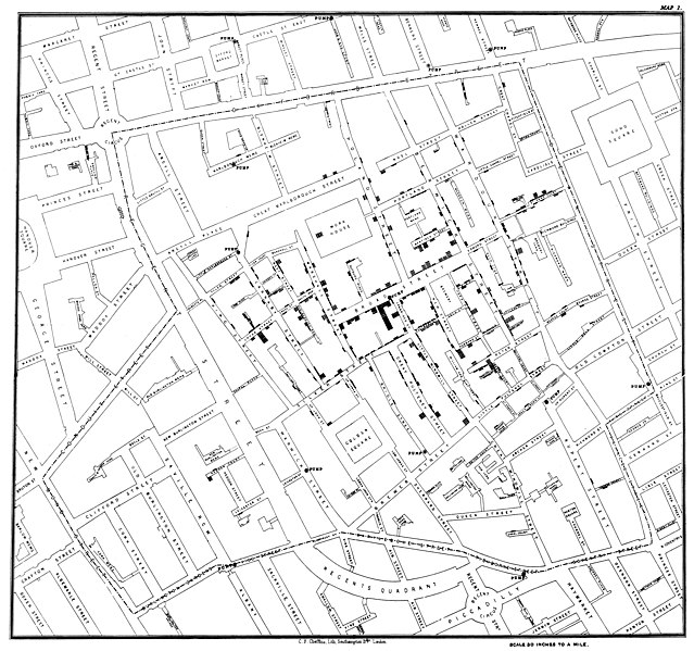
Original map made by John Snow in 1854. Cholera cases are highlighted in black, showing the clusters of cholera cases (indicated by stacked rectangles) in the London epidemic of 1854. The map was created in order to better understand the pattern of cholera spread in the 1854 Broad Street cholera outbreak, which Snow would use as an example of how cholera spread via the fecal-oral route through water systems as opposed to the miasma theory of disease spread. The contaminated pump is located at the intersection of Broad Street and Cambridge Street (now Lexington Street), running into Little Windmill Street. The map marks an important part of the development of epidemiology as a field, and of disease mapping as a whole. |
|||||||||
| Datum | ||||||||||
| Bron |
Map of the book "On the Mode of Communication of Cholera" by John Snow, originally published in 1854 by C.F. Cheffins, Lith, Southhampton Buildings, London, England. The uploaded images is a digitally enhanced version found on the UCLA Department of Epidemiology website. |
|||||||||
| Skepper | ||||||||||
| Geotemporal data | ||||||||||
| Bounding box |
|
|||||||||
| Georeferencing | ||||||||||
| Ander weergawes | File:Snow-cholera-map.jpg | |||||||||

|
Lisensiëring
|
This is a faithful photographic reproduction of a two-dimensional, public domain work of art. The work of art itself is in the public domain for the following reason:
The official position taken by the Wikimedia Foundation is that "faithful reproductions of two-dimensional public domain works of art are public domain".
This photographic reproduction is therefore also considered to be in the public domain in the United States. In other jurisdictions, re-use of this content may be restricted; see Reuse of PD-Art photographs for details. | ||||
Oorspronklike oplaailogboek
(All user names refer to en.wikipedia)
- 2006-12-30 23:15 Rewardiv 3045×2840×8 (1183741 bytes) Original map made by John Snow in 1854, copied from http://matrix.msu.edu/~johnsnow/images/online_companion/chapter_images/fig12-5.jpg Author died in 1858, material is public domain.
Lêergeskiedenis
Klik op die datum/tyd om te sien hoe die lêer destyds gelyk het.
| Datum/Tyd | Duimnael | Dimensies | Gebruiker | Opmerking | |
|---|---|---|---|---|---|
| huidig | 21:19, 16 November 2020 | | 20 124 × 18 877 (18,38 MG) | Artoria2e5 | Reverted to version as of 14:12, 6 May 2020 (UTC) |
| 21:12, 16 November 2020 |  | 1 092 × 1 024 (320 KG) | Artoria2e5 | temporarily reduce size for wikimaps | |
| 14:12, 6 Mei 2020 |  | 20 124 × 18 877 (18,38 MG) | Sette-quattro | higher resolution version | |
| 13:53, 22 Junie 2007 |  | 3 045 × 2 840 (1,13 MG) | Finavon | {{Information |Description=Original map made by John Snow in 1854, copied from http://matrix.msu.edu/~johnsnow/images/online_companion/chapter_images/fig12-5.jpg Author died in 1858, material is public domain. |Source=Originally from [http://en.wikipedi |
Lêergebruik
Daar is geen bladsye wat dié lêer gebruik nie.
Globale lêergebruik
Die volgende ander wiki's gebruik hierdie lêer:
- Gebruik in ar.wikipedia.org
- Gebruik in bg.wikipedia.org
- Gebruik in bh.wikipedia.org
- Gebruik in bn.wikipedia.org
- Gebruik in ca.wikipedia.org
- Gebruik in de.wikipedia.org
- Gebruik in de.wikiversity.org
- Gebruik in en.wikipedia.org
- Human geography
- Natural experiment
- Water purification
- Public health
- John Snow
- Slow sand filter
- Category talk:Geography
- Portal:Medicine
- Health geography
- Thematic map
- User talk:Mathwhiz 29
- Statistical graphics
- Wikipedia:Featured pictures/Diagrams, drawings, and maps/Maps
- 1846–1860 cholera pandemic
- 1854 Broad Street cholera outbreak
- Talk:1854 Broad Street cholera outbreak
- User:Aetarrell/Practice
- GIS and public health
- Wikipedia:WikiProject Medicine/Recognized content
- Dot distribution map
- History of water filters
- Wikipedia:Reference desk/Archives/Humanities/2010 August 24
- History of water supply and sanitation
- User talk:Sarason
- Portal:Geography/Intro/Image
- User talk:Smileguy91
- User:Life in General/Userboxes/HumanGeography
- User talk:Gwooodward
- Portal:Geography/Intro/6
- User:Wouterstomp/test
- Charles Cheffins
- User talk:Khamar
- User talk:Joshualouie711
- User talk:OfficialNeon
Wys meer globale gebruik van die lêer.