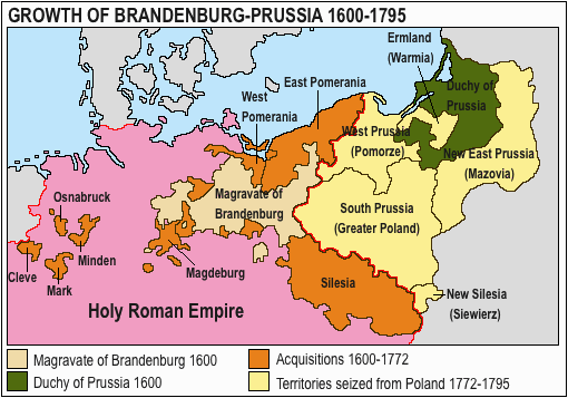
Lêer:Acprussiamap2.gif
Geen hoër resolusie is beskikbaar nie.
Acprussiamap2.gif (510 × 357 piksels, lêergrootte: 27 KG, MIME-tipe: image/gif, 0,1 s)

This image was copied from wikipedia:pt. The original description was:
Licença GNU, fonte en:Wikipedia.

|
Toestemming word verleen tot die kopiëring, verspreiding en/of wysiging van hierdie dokument onder die voorwaardes van die GNU-lisensie vir vrye dokumentasie, weergawe 1.2 of enige latere weergawe uitgegee deur die Stigting vir Vrye Sagteware, sonder Invariante Dele, geen Voorbladtekste en geen Agterbladtekste. 'n Kopie van hierdie lisensie is ingesluit in die afdeling getiteld GNU Free Documentation License. |
| Hierdie lêer is gelisensieer onder die Creative Commons Erkenning-Insgelyks Deel 3.0 Onoorgedraagde lisensie. | ||
| ||
| This licensing tag was added to this file as part of the GFDL licensing update. |

|
This map has been uploaded by Electionworld from en.wikipedia.org to enable the |
Growth of Prussia en:Image:Ac.prussiamap2.gif

|
This historical map image could be re-created using vector graphics as an SVG file. This has several advantages; see Commons:Media for cleanup for more information. If an SVG form of this image is available, please upload it and afterwards replace this template with
{{vector version available|new image name}}.
It is recommended to name the SVG file “Acprussiamap2.svg”—then the template Vector version available (or Vva) does not need the new image name parameter. |
Lêergeskiedenis
Klik op die datum/tyd om te sien hoe die lêer destyds gelyk het.
| Datum/Tyd | Duimnael | Dimensies | Gebruiker | Opmerking | |
|---|---|---|---|---|---|
| huidig | 13:17, 15 Maart 2020 | | 510 × 357 (27 KG) | E-960 | Ermland, correction. |
| 12:50, 15 Maart 2020 |  | 510 × 357 (27 KG) | E-960 | Names of territories and format. | |
| 19:44, 1 Junie 2009 |  | 510 × 357 (14 KG) | Hohum | Changed colours to more cartographic, less garish. Made sea blue instead of portions of land. | |
| 18:36, 25 Augustus 2006 |  | 510 × 357 (15 KG) | LeonardoG | This image was copied from wikipedia:pt. The original description was: Licença GNU, fonte en:Wikipedia. {{GFDL}} en:Image:Ac.prussiamap2.gif {| border="1" ! date/time || username || resolution || size || edit summary |---- | |} |
Lêergebruik
Die volgende bladsy gebruik dié lêer:
Globale lêergebruik
Die volgende ander wiki's gebruik hierdie lêer:
- Gebruik in ar.wikipedia.org
- Gebruik in ast.wikipedia.org
- Gebruik in bg.wikipedia.org
- Gebruik in ca.wikipedia.org
- Gebruik in cs.wikipedia.org
- Gebruik in el.wikipedia.org
- Gebruik in en.wikipedia.org
- History of Germany
- House of Hohenzollern
- Prussia
- Margraviate of Brandenburg
- Prussian Army
- Territorial evolution of Germany
- Subdivisions of the Polish–Lithuanian territories following the partitions
- Prussian Partition
- 18th-century history of Germany
- Brandenburg–Pomeranian conflict
- Treaty of Vossem (1673)
- User:Falcaorib
- User:JMvanDijk/Sandbox 9/Box 15/Box 3
- Gebruik in es.wikipedia.org
- Gebruik in et.wikipedia.org
- Gebruik in eu.wikipedia.org
- Gebruik in fa.wikipedia.org
- Gebruik in fi.wikipedia.org
- Gebruik in fr.wikipedia.org
- Gebruik in he.wikipedia.org
- Gebruik in hy.wikipedia.org
- Gebruik in it.wikipedia.org
Wys meer globale gebruik van die lêer.