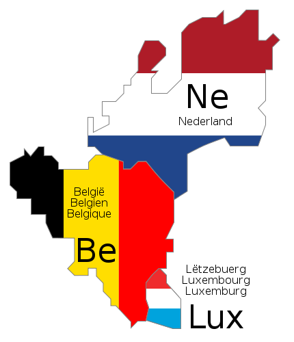
Lêer:Benelux schematic map.svg

Size of this PNG preview of this SVG file: 430 × 500 piksels. Ander resolusies: 206 × 240 piksels | 413 × 480 piksels | 660 × 768 piksels | 881 × 1 024 piksels | 1 761 × 2 048 piksels.
Oorspronklike lêer (SVG-lêer, normaalweg 430 × 500 piksels, lêergrootte: 20 KG)
Lêergeskiedenis
Klik op die datum/tyd om te sien hoe die lêer destyds gelyk het.
| Datum/Tyd | Duimnael | Dimensies | Gebruiker | Opmerking | |
|---|---|---|---|---|---|
| huidig | 10:46, 17 Junie 2009 |  | 430 × 500 (20 KG) | Bibi Saint-Pol | fix internal trouble with text nodes |
| 10:28, 17 Junie 2009 |  | 430 × 500 (21 KG) | Bibi Saint-Pol | {{inkscape}} {{Information |Description= {{en|1=Schematic map of w:en:Benelux. The country names are given in the official languages of each state.}} {{fr|1=Carte schématique du w:fr:Benelux. Les noms des pays sont indiqués dans les langues of |
Lêergebruik
Die volgende bladsy gebruik dié lêer:
Globale lêergebruik
Die volgende ander wiki's gebruik hierdie lêer:
- Gebruik in als.wikipedia.org
- Gebruik in ar.wikipedia.org
- Gebruik in be-tarask.wikipedia.org
- Gebruik in be.wikipedia.org
- Gebruik in bg.wikipedia.org
- Gebruik in br.wikipedia.org
- Gebruik in ca.wikipedia.org
- Gebruik in cs.wikipedia.org
- Gebruik in cy.wikipedia.org
- Gebruik in de.wikipedia.org
- Gebruik in el.wikipedia.org
- Gebruik in en.wikipedia.org
- Gebruik in eo.wikipedia.org
- Gebruik in fa.wikipedia.org
- Gebruik in fo.wikipedia.org
- Gebruik in frr.wikipedia.org
- Gebruik in fr.wikipedia.org
- Gebruik in fy.wikipedia.org
- Gebruik in gl.wikipedia.org
- Gebruik in hr.wikipedia.org
- Gebruik in ht.wikipedia.org
- Gebruik in ia.wikipedia.org
- Gebruik in id.wikipedia.org
- Gebruik in is.wikipedia.org
- Gebruik in jv.wikipedia.org
- Gebruik in ko.wikipedia.org
- Gebruik in la.wikipedia.org
- Gebruik in lb.wikipedia.org
- Gebruik in lb.wiktionary.org
- Gebruik in nds.wikipedia.org
- Gebruik in nl.wikibooks.org
- Gebruik in nn.wikipedia.org
- Gebruik in no.wikipedia.org
Wys meer globale gebruik van die lêer.


