Lêer:Carte de Chypre.svg

Size of this PNG preview of this SVG file: 702 × 411 piksels. Ander resolusies: 320 × 187 piksels | 640 × 375 piksels | 1 024 × 600 piksels | 1 280 × 749 piksels | 2 560 × 1 499 piksels.
Oorspronklike lêer (SVG-lêer, normaalweg 702 × 411 piksels, lêergrootte: 149 KG)
| Beskrywing |
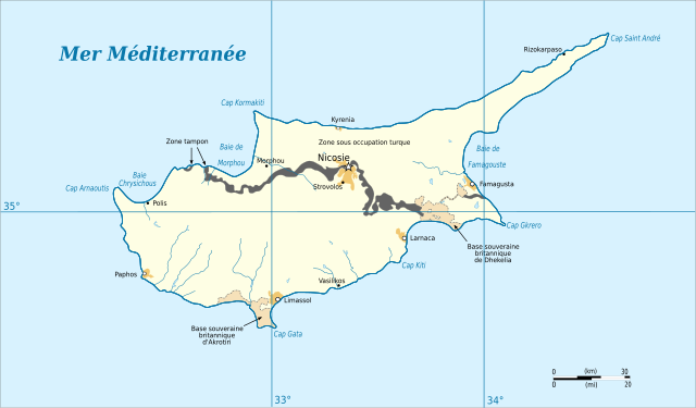
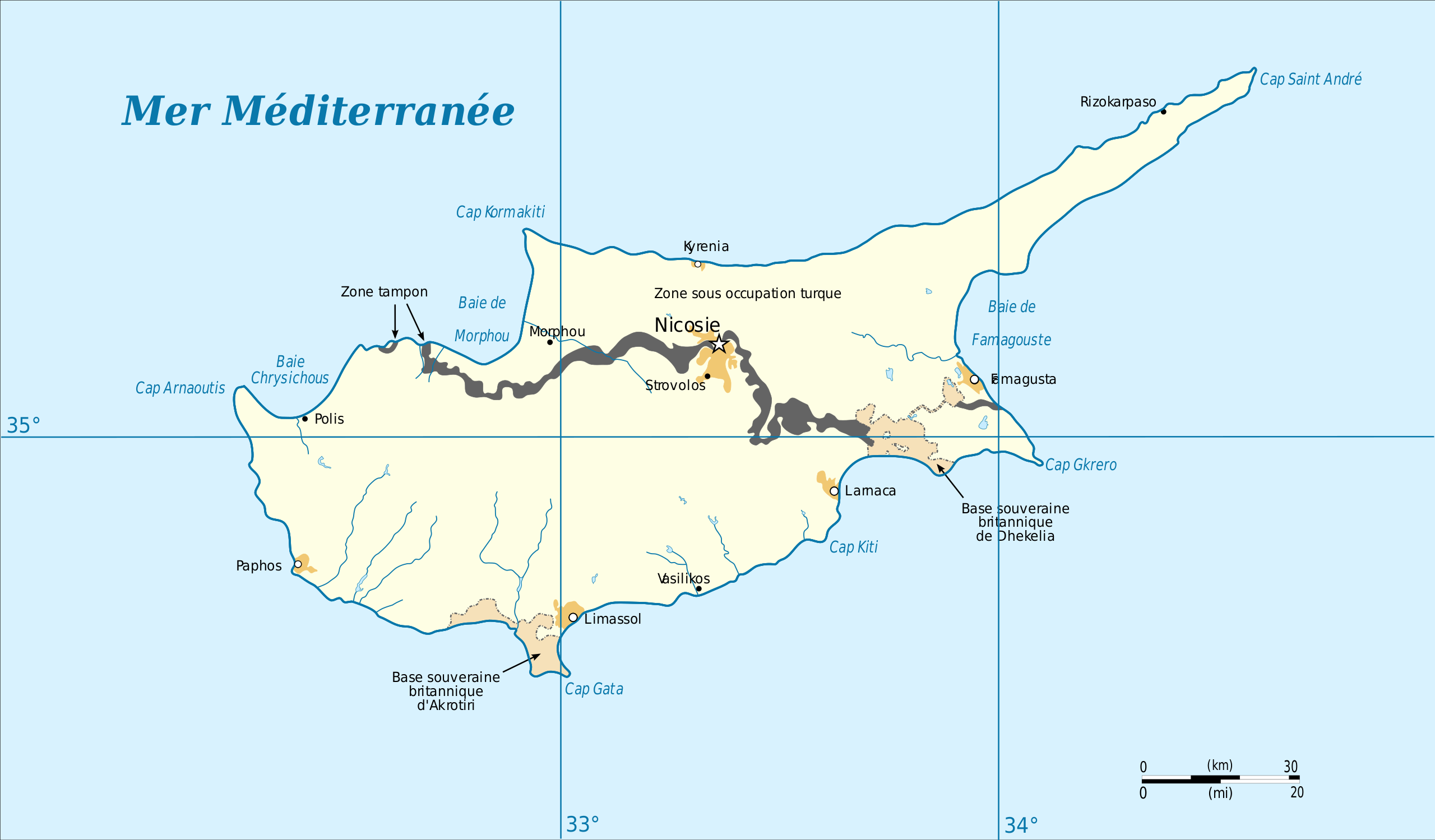
Français : Carte de Chypre English: Cyprus Map |
| Datum | (UTC) |
| Bron | |
| Outeur |
|
| Ander weergawes |
|


| This is a retouched picture, which means that it has been digitally altered from its original version. Modifications: passage total au svg. The original can be viewed here: Carte de Chypre.png:
|
This work is in the public domain in the United States because it is a work prepared by an officer or employee of the United States Government as part of that person’s official duties under the terms of Title 17, Chapter 1, Section 105 of the US Code.
Note: This only applies to original works of the Federal Government and not to the work of any individual U.S. state, territory, commonwealth, county, municipality, or any other subdivision. This template also does not apply to postage stamp designs published by the United States Postal Service since 1978. (See § 313.6(C)(1) of Compendium of U.S. Copyright Office Practices). It also does not apply to certain US coins; see The US Mint Terms of Use.
|
 | |
| Hierdie lêer is geïdentifiseer as vry van bekende beperkings onder kopiereg, insluitend alle verwante en naburige regte. | ||
Oorspronklike oplaailogboek
This image is a derivative work of the following images:
- File:Carte_de_Chypre.png licensed with PD-USGov
- 2009-05-14T14:39:07Z File Upload Bot (Magnus Manske) 630x321 (50700 Bytes) {{BotMoveToCommons|fr.wikipedia|year={{subst:CURRENTYEAR}}|month={{subst:CURRENTMONTHNAME}}|day={{subst:CURRENTDAY}}}} {{Information |Description={{fr|1=Carte de Chypre. '''Source :''' [[:fr:CIA World Factbook|]], http://www.
Uploaded with derivativeFX
Lêergeskiedenis
Klik op die datum/tyd om te sien hoe die lêer destyds gelyk het.
| Datum/Tyd | Duimnael | Dimensies | Gebruiker | Opmerking | |
|---|---|---|---|---|---|
| huidig | 19:59, 2 November 2011 | | 702 × 411 (149 KG) | Treehill | correction, le nom du cap se traduit |
| 13:25, 6 November 2010 |  | 702 × 411 (149 KG) | Treehill | ajout des degrés | |
| 12:55, 6 November 2010 |  | 702 × 411 (145 KG) | Treehill | {{Information |Description={{fr|Carte de Chypre}}{{en|Cyprus Map}} |Source=*File:Carte_de_Chypre.png |Date=2010-11-06 12:54 (UTC) |Author=*File:Carte_de_Chypre.png: CIA World Factbook *derivative work: ~~~ |Permission= |other_versions= }} {{R |
Lêergebruik
Daar is geen bladsye wat dié lêer gebruik nie.
Globale lêergebruik
Die volgende ander wiki's gebruik hierdie lêer:
- Gebruik in csb.wikipedia.org
- Gebruik in fr.wikipedia.org
- Ligne verte (Chypre)
- Portail:Relations internationales/Lumière sur...
- Chypre (pays)
- Wikipédia:Sélection/Chypre
- Wikipédia:Sélection/Europe
- Partition de Chypre
- Procédure d'adhésion de Chypre à l'Union européenne
- Wikipédia:Sélection/Turquie
- Wikipédia:Lumière sur/Partition de Chypre
- Wikipédia:Sélection/Moyen-Orient
- Wikipédia:Lumière sur/Février 2014
- Portail:Asie/Lumière sur…/Bons articles
- Wikipédia:Sélection/Frontière
- Réfugié chypriote
- Tassos Isaac
- Gebruik in la.wikipedia.org
- Gebruik in pcd.wikipedia.org
- Gebruik in uk.wikipedia.org