Lêer:Majorca, Spain - NASA Earth Observatory.jpg
Majorca,_Spain_-_NASA_Earth_Observatory.jpg (720 × 540 piksels, lêergrootte: 150 KG, MIME-tipe: image/jpeg)
Opsomming
| Beskrywing |
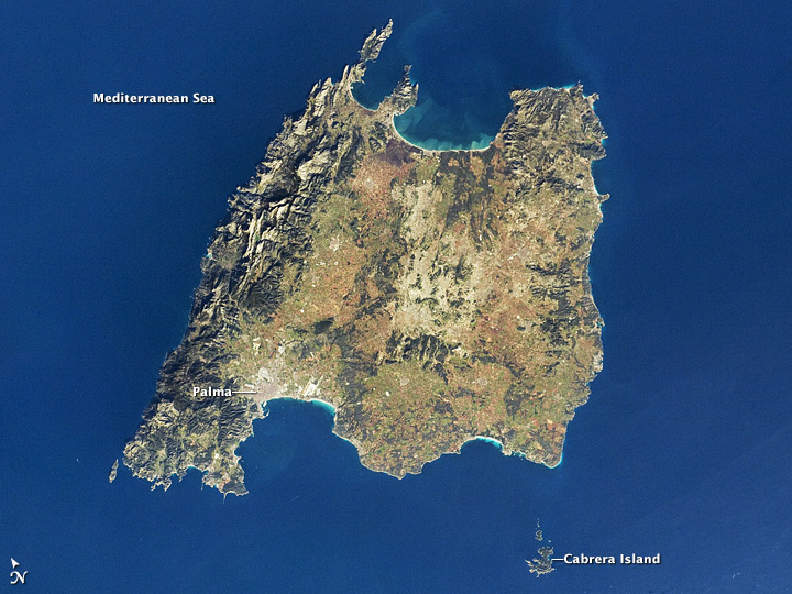
To download the full resolution and other files go to: earthobservatory.nasa.gov/IOTD/view.php?id=77089&src=... The Balearic Islands are an archipelago located in the Mediterranean Sea to the southwest of Spain. Catalan—the native tongue—and Spanish are the official languages. The islands are an autonomous community and province of Spain, located about midway between the southeastern coastline of Spain and the northern coastline of Algeria. This astronaut photograph from the International Space Station highlights the large island of Majorca (also known as Mallorca in Spanish), on which the provincial capital of Palma is located. Like the other Balearic Islands, Majorca is a popular holiday destination for Europeans, with tourism forming a major part of the island’s economy. The 5,400 square kilometer (2,100 square mile) island offers many recreational opportunities, with mountainous regions along the northwest coastline and eastern third. The central region of Majorca includes agricultural lands (tan, light brown, and green, image center), forested patches and corridors (dark green, image center), and urban centers (gray). Diving is a popular activity for those visiting the coastal beaches. In addition to Majorca, the other major islands of the archipelago include Ibiza, Formentera, and Minorca. The small island of Cabrera to the southwest (image lower right) hosts the Parc Nacional de l’Arxipélag de Cabrera. Astronaut photograph ISS030-E-30290 was acquired on December 31, 2011, with a Nikon D2Xs digital camera using a 60 mm lens, and is provided by the ISS Crew Earth Observations experiment and Image Science & Analysis Laboratory, Johnson Space Center. The image was taken by the Expedition 30 crew. The image has been cropped and enhanced to improve contrast, and lens artifacts have been removed. The International Space Station Program supports the laboratory as part of the ISS National Lab to help astronauts take pictures of Earth that will be of the greatest value to scientists and the public, and to make those images freely available on the Internet. Additional images taken by astronauts and cosmonauts can be viewed at the NASA/JSC Gateway to Astronaut Photography of Earth. Caption by William L. Stefanov, Jacobs Technology/ESCG at NASA-JSC. The Earth Observatory's mission is to share with the public the images, stories, and discoveries about climate and the environment that emerge from NASA research, including its satellite missions, in-the-field research, and climate models. Like us on Facebook Follow us on Twitter Add us to your circles on Google+ |
| Datum | |
| Bron | Majorca, Spain |
| Outeur | NASA's Earth Observatory |
| Kameraligging | | Hierdie en ander beelde in: OpenStreetMap |
|---|
Lisensiëring
- U is vry:
- om te deel – die werk kopieer, versprei en deurgee
- om te hermeng – om die werk aan te pas
- Onder die volgende voorwaardes:
- naamsvermelding – U moet die nodige krediet gee, 'n skakel na die lisensie verskaf en aandui of daar veranderinge aangebring is. U mag dit op enige redelike manier doen, maar nie op enige manier wat daarop dui dat die lisensiegewer u of u gebruik onderskryf nie.
| This image was originally posted to Flickr by NASA Earth Observatory at https://www.flickr.com/photos/68824346@N02/6830431935. It was reviewed on 2 Julie 2012 by FlickreviewR and was confirmed to be licensed under the terms of the cc-by-2.0. |
Lêergeskiedenis
Klik op die datum/tyd om te sien hoe die lêer destyds gelyk het.
| Datum/Tyd | Duimnael | Dimensies | Gebruiker | Opmerking | |
|---|---|---|---|---|---|
| huidig | 17:10, 2 Julie 2012 | | 720 × 540 (150 KG) | Dzlinker | == {{int:filedesc}} == {{Information |Description=To download the full resolution and other files go to: [http://earthobservatory.nasa.gov/IOTD/view.php?id=77089&src=flickr earthobservatory.nasa.gov/IOTD/view.php?id=77089&src=...] The Balearic Islands... |
Lêergebruik
Die volgende bladsy gebruik dié lêer:
Globale lêergebruik
Die volgende ander wiki's gebruik hierdie lêer:
- Gebruik in it.wikiquote.org