Hierdie lêer kom vanaf Wikimedia Commons en kan ook in ander projekte gebruik word.
Die beskrywing op die lêer se inligtingsblad word hieronder weergegee.
Opsomming
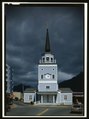
English: WEST FRONT - Saint Michael's Cathedral, Lincoln Street, Sitka, Sitka Borough, AK
()
one of the photographers employed by the U.S. National Park Service on the Historic American Building Survey and Historic American Engineering Record projects
When reusing please credit: Library of Congress, Prints & Photographs Division, HABS AK,17-SITKA,1-25 (CT)
Deze banner zegt niets over de auteursrechten die van toepassing zijn. Een normale auteursrechten-tag is nodig.Zie Commons:Licensing voor meer informatie.
Opmerkings
Significance: The Cathedral was built in the period 1844-1848. It was the spiritual center for the Russian Orthodox Church in Alaska from the date of completion until 1872 and from 1905 to the present time. In the interim period, the center for the Orthodox faith was moved to San Francisco. In 1905 the Episcopal See moved to New York and the St. Michael's Mission was raised to the rank of archdiocese. It is a splendid and typical example of Eastern Orthodox Church architecture in Alaska. / The seat of the Russian Orthodox church in Alaska since the previous building was constructed here in the 1840s, St. Michael's Cathedral has an architectural presence that reflects its spiritual importance. This building is a reconstruction based on HABS drawings of the 1840s log church that burned in 1966. The reconstruction is a faithful one, maintaining the cruciform plan, domed silhouette, and modest interior brightened by a dazzling array of icons and golden treasures.
Survey number: HABS AK-1
Building/structure dates: 1844- 1848 Initial Construction

.jpg)


