Lêer:11 of 'History of the Boers in South Africa ... with three maps' (11191958004), crop3.jpg

Oorspronklike lêer (611 × 640 piksels, lêergrootte: 82 KG, MIME-tipe: image/jpeg)
,_crop3.jpg)
Opsomming
| Beskrywing |
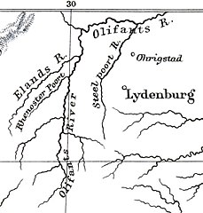
View this map on the BL Georeferencer service. Image taken from: Title: "History of the Boers in South Africa ... with three maps" Author: THEAL, George McCall. Shelfmark: "British Library HMNTS 9061.eee.18." Page: 11 Place of Publishing: London Date of Publishing: 1887 Publisher: Sonnenschein & Co. Issuance: monographic Identifier: 003607007 Explore: Find this item in the British Library catalogue, 'Explore'. Download the PDF for this book (volume: 0) Image found on book scan 11 (NB not necessarily a page number) Download the OCR-derived text for this volume: (plain text) or (json) Click here to see all the illustrations in this book and click here to browse other illustrations published in books in the same year. Order a higher quality version from here.
|
||
| Datum | |||
| Bron | Image taken from page 11 of 'History of the Boers in South Africa ... with three maps' | ||
| Outeur | The British Library | ||
| Toestemming (Hergebruik van die lêer) |
The British Library @ Flickr Commons | ||
| Ander weergawes |
.jpg) |
Lisensiëring
This image was taken from Flickr's The Commons. The uploading organization may have various reasons for determining that no known copyright restrictions exist, such as:
More information can be found at https://flickr.com/commons/usage/. Please add additional copyright tags to this image if more specific information about copyright status can be determined. See Commons:Licensing for more information. |
| This image was originally posted to Flickr by The British Library at https://flickr.com/photos/12403504@N02/11191958004 (archive). It was reviewed on 2 Februarie 2018 by FlickreviewR 2 and was confirmed to be licensed under the terms of the No known copyright restrictions. |

|
This file has been provided by the British Library from its digital collections.
|
Lêergeskiedenis
Klik op die datum/tyd om te sien hoe die lêer destyds gelyk het.
| Datum/Tyd | Duimnael | Dimensies | Gebruiker | Opmerking | |
|---|---|---|---|---|---|
| huidig | 14:58, 10 April 2022 | | 611 × 640 (82 KG) | JMK | clean background |
| 22:07, 17 Mei 2018 |  | 611 × 640 (90 KG) | JMK | {{Information |description ={{en|1='''[http://britishlibrary.georeferencer.com/id/11191958004 View this map on the BL Georeferencer service.]'''}} |source =[https://www.flickr.com/photos/britishlibrary/11191958004/ Image taken from page 11 of 'History of the Boers in South Africa ... with three maps'] |author =[https://www.flickr.com/people/12403504@N02 The British Library] |date =2013 }} Category:Rivers of South Africa |
Lêergebruik
Die volgende 2 bladsye gebruik dié lêer:
Globale lêergebruik
Die volgende ander wiki's gebruik hierdie lêer:
- Gebruik in arz.wikipedia.org
- Gebruik in ceb.wikipedia.org
- Gebruik in en.wikipedia.org
- Gebruik in www.wikidata.org
,_crop3.jpg)