Lêer:Map of Sealand with territorial waters.png

Oorspronklike lêer(1 174 × 1 200 piksels, lêergrootte: 55 KG, MIME-tipe: image/png)

Hierdie lêer kom vanaf Wikimedia Commons en kan ook in ander projekte gebruik word. Die beskrywing op die lêer se inligtingsblad word hieronder weergegee.

Beskrywing

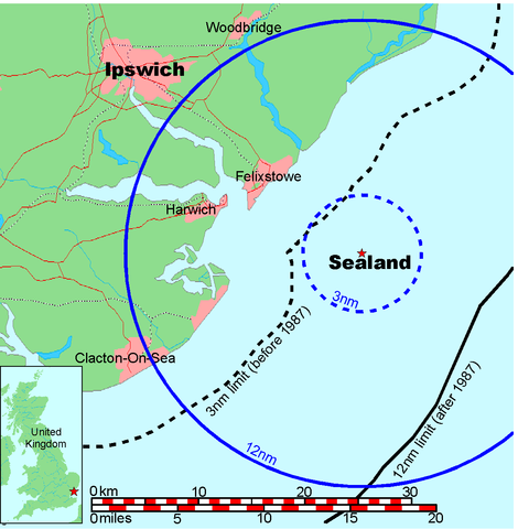
Map of Sealand

This is a map of the coast of England near Ipswich, showing the location of Sealand. The boundaries of the territorial water of the United Kingdom are also drawn, both the 3 nautical mile limit (5.556km) before 1987 and the 12nm limit (22.22km) after 1987. The same radii are also given around Sealand.

Note that these boundaries are derived based on the circular distance from the coastline, and not copied from official maps. This map is not suitable for navigation or for determining the boundaries of the UK territorial waters for legal or other purposes.

Skepper
Map generated by DEMIS World Map Server and edited by Chris 73
Toestemming
(Hergebruik van die lêer)


Licensing:

This image was created by Chris 73. The image is licensed under a dual license; please choose either of the two licenses below as desired. Attribution to Wikipedia or another project of the Wikimedia foundation is required for both licenses if the image is used outside of projects of the Wikimedia foundation. Attribution to me is not required.

GNU head Permission is granted to copy, distribute and/or modify this document under the terms of the GNU Free Documentation License, Version 1.3 or any later version published by the Free Software Foundation; with no Invariant Sections, no Front-Cover Texts, and no Back-Cover Texts. A copy of the license is included in the section entitled GNU Free Documentation License.

w:af:Creative Commons
naamsvermelding insgelyks
Hierdie lêer is gelisensieer onder die Creative Commons Erkenning-Insgelyks Deel 3.0 Onoorgedraagde lisensie.
Naamsvermelding: Chris 73 / Wikimedia Commons
U is vry:
  • om te deel – die werk kopieer, versprei en deurgee
  • om te hermeng – om die werk aan te pas
Onder die volgende voorwaardes:
  • naamsvermelding – U moet die nodige krediet gee, 'n skakel na die lisensie verskaf en aandui of daar veranderinge aangebring is. U mag dit op enige redelike manier doen, maar nie op enige manier wat daarop dui dat die lisensiegewer u of u gebruik onderskryf nie.
  • insgelyks – As u die materiaal hermix, transformeer of voortbou, moet u u bydraes versprei onder die dieselfde of versoenbare lisensie as die oorspronklike.

"I want to use the image. How do I do that?"

You can use this image freely for any purpose, including commercial use, provided that you license it under one of the above licenses. My suggestion is to use the following text:

This Wikipedia and Wikimedia Commons image is from the user Chris 73 and is freely available at //commons.wikimedia.org/wiki/File:Map_of_Sealand_with_territorial_waters.png under the creative commons cc-by-sa 3.0 license.

For privacy reasons please use only "Chris 73" as author. If necessary, please translate the text in your language. For electronic use please include the links in the text as shown, for printed use please print the text as shown. If you use the image I would appreciate it if you would let me know on my talk page, but this is not required as long as you follow one of the above licenses.


 Geotemporal data
Bounding box
N: 52.1374339°N
W: 0.9973602°E E: 1.6619722°E
S: 51.6274989°N
Georeferencing View the georeferenced map in the Wikimaps Warper

Captions

Add a one-line explanation of what this file represents

Items portrayed in this file

uitbeelding

media type Engels

image/png

checksum Engels

845a9e08cbe7ed93bae6eeabe454399a76e3324f

data size Engels

56 131 greep

height Engels

1 200 pieksel

width Engels

1 174 pieksel

Lêergeskiedenis

Klik op die datum/tyd om te sien hoe die lêer destyds gelyk het.

Datum/TydDuimnaelDimensiesGebruikerOpmerking
huidig19:41, 9 Julie 2006Duimnaelskets vir weergawe vanaf 19:41, 9 Julie 20061 174 × 1 200 (55 KG)Chris 73update
10:00, 26 Januarie 2005Duimnaelskets vir weergawe vanaf 10:00, 26 Januarie 20051 024 × 1 046 (50 KG)Chris 73

Die volgende bladsy gebruik dié lêer:

Globale lêergebruik

Die volgende ander wiki's gebruik hierdie lêer: