Lêer:Wpdms aq block 1614.jpg

Grootte van hierdie voorskou: 429 × 599 piksels. Ander resolusies: 172 × 240 piksels | 344 × 480 piksels | 550 × 768 piksels | 733 × 1 024 piksels | 1 466 × 2 048 piksels | 5 744 × 8 021 piksels.
Oorspronklike lêer (5 744 × 8 021 piksels, lêergrootte: 7,61 MG, MIME-tipe: image/jpeg)
Opsomming
| Beskrywing |
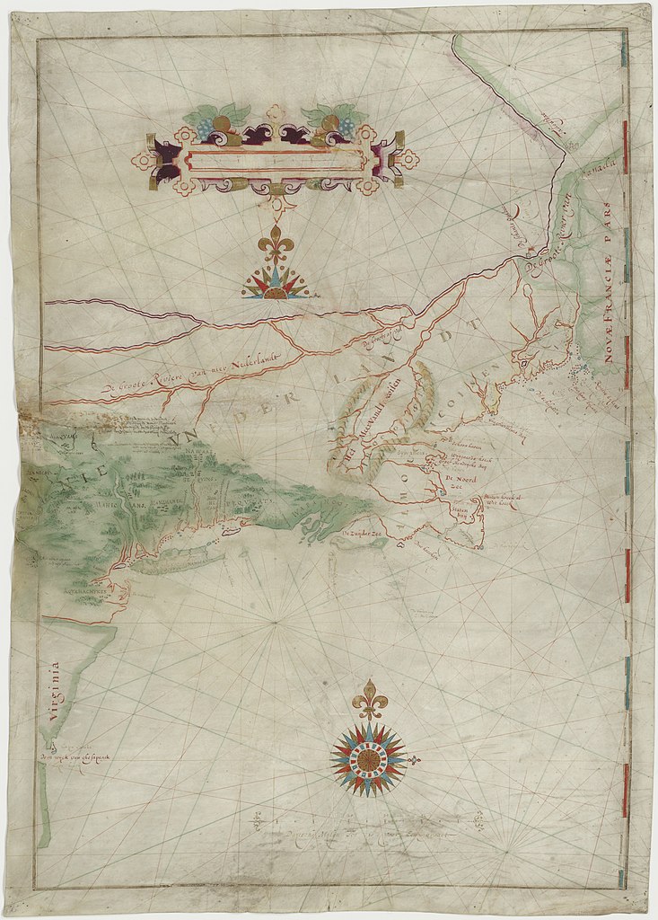
English: Map made by w:Adriaen Block of his 1614 expedition to North America. It is the first map to show Long Island as an island. It is also the first appearance of the term New Netherland to describe the colony (17th century drawing). |
|||||||||
| Datum | ||||||||||
| Bron | digitalized by the Dutch National Archive (perm link) | |||||||||
| Skepper | ||||||||||
| Geotemporal data | ||||||||||
| Bounding box |
|
|||||||||
| Georeferencing | ||||||||||
| Ander weergawes | File:The figurative map of Adriaen Block (NYPL Hades-118535-54659).tif | |||||||||
Lisensiëring
|
This is a faithful photographic reproduction of a two-dimensional, public domain work of art. The work of art itself is in the public domain for the following reason:
The official position taken by the Wikimedia Foundation is that "faithful reproductions of two-dimensional public domain works of art are public domain".
This photographic reproduction is therefore also considered to be in the public domain in the United States. In other jurisdictions, re-use of this content may be restricted; see Reuse of PD-Art photographs for details. | ||||
Lêergeskiedenis
Klik op die datum/tyd om te sien hoe die lêer destyds gelyk het.
| Datum/Tyd | Duimnael | Dimensies | Gebruiker | Opmerking | |
|---|---|---|---|---|---|
| huidig | 18:41, 18 Mei 2021 | | 5 744 × 8 021 (7,61 MG) | Ciell | Larger digitalisation from the Dutch National Archive |
| 17:15, 17 Februarie 2012 |  | 456 × 640 (104 KG) | Gladiool | Better quality version of the same image. Found at [http://www.stonybrook.edu/libmap/coordinates/seriesa/no5/block.jpg]. | |
| 21:00, 28 September 2005 |  | 350 × 499 (31 KG) | Longbow4u | *Description:Map made by w:Adriaen Block of his 1614 expedition to North America. It is the first map to show Long Island as an island. It is also the first appearance of the term New Netherland to describe the colony (17th century drawing). *Sour |
Lêergebruik
Die volgende bladsy gebruik dié lêer:
Globale lêergebruik
Die volgende ander wiki's gebruik hierdie lêer:
- Gebruik in azb.wikipedia.org
- Gebruik in be.wikipedia.org
- Gebruik in ca.wikipedia.org
- Gebruik in de.wikipedia.org
- Gebruik in en.wikipedia.org
- Gebruik in es.wikipedia.org
- Gebruik in et.wikipedia.org
- Gebruik in fa.wikipedia.org
- Gebruik in fr.wikipedia.org
- Gebruik in fy.wikipedia.org
- Gebruik in hr.wikipedia.org
- Gebruik in is.wikipedia.org
- Gebruik in it.wikipedia.org
- Gebruik in ja.wikipedia.org
- Gebruik in ml.wikipedia.org
- Gebruik in nl.wikipedia.org
- Gebruik in ru.wikipedia.org
- Gebruik in sh.wikipedia.org
- Gebruik in uk.wikipedia.org
- Gebruik in zh.wikipedia.org